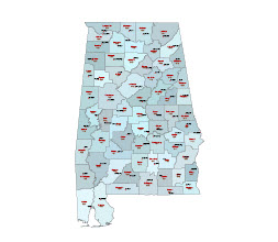
Alabama county seats and FIPS codes is a vector, Illustrator map.
The Federal Information Processing Standard (FIPS) code is a set of standards that are developed and maintained by the National Institute of Standards and Technology (NIST), an agency of the United States Department of Commerce. The purpose of the FIPS codes is to ensure that information technology products used by federal agencies are secure and reliable.
Alabama county seats and FIPS codes
FIPS codes are five-digit numeric codes that are used to identify various elements of information technology, including algorithms, data formats, and protocols. For example, FIPS 140-2 is a standard for security of cryptographic modules, and FIPS 201 is a standard for Personal Identity Verification (PIV) of Federal Employees and Contractors.
FIPS codes are widely used in the public and private sectors and are an important aspect of information security in the United States. They help organizations ensure the security and privacy of their data and systems and provide a consistent approach to information technology.
More from FIPS code:
Federal Communications Commission
https://transition.fcc.gov/oet/info/maps/census/fips/fips.txt
Layers:
- County seats names
- County name-fips code
- County seat sign
- County shape
Other Alabama map:
Alabama 5 digit zip code vector map
| 01001 | Autauga County | |
| 01003 | Baldwin County | |
| 01005 | Barbour County | |
| 01007 | Bibb County | |
| 01009 | Blount County | |
| 01011 | Bullock County | |
| 01013 | Butler County | |
| 01015 | Calhoun County | |
| 01017 | Chambers County | |
| 01019 | Cherokee County | |
| 01021 | Chilton County | |
| 01023 | Choctaw County | |
| 01025 | Clarke County | |
| 01027 | Clay County | |
| 01029 | Cleburne County | |
| 01031 | Coffee County | |
| 01033 | Colbert County | |
| 01035 | Conecuh County | |
| 01037 | Coosa County | |
| 01039 | Covington County | |
| 01041 | Crenshaw County | |
| 01043 | Cullman County | |
| 01045 | Dale County | |
| 01047 | Dallas County | |
| 01049 | DeKalb County | |
| 01051 | Elmore County | |
| 01053 | Escambia County | |
| 01055 | Etowah County | |
| 01057 | Fayette County | |
| 01059 | Franklin County | |
| 01061 | Geneva County | |
| 01063 | Greene County | |
| 01065 | Hale County | |
| 01067 | Henry County | |
| 01069 | Houston County | |
| 01071 | Jackson County | |
| 01073 | Jefferson County | |
| 01075 | Lamar County | |
| 01077 | Lauderdale County | |
| 01079 | Lawrence County | |
| 01081 | Lee County | |
| 01083 | Limestone County | |
| 01085 | Lowndes County | |
| 01087 | Macon County | |
| 01089 | Madison County | |
| 01091 | Marengo County | |
| 01093 | Marion County | |
| 01095 | Marshall County | |
| 01097 | Mobile County | |
| 01099 | Monroe County | |
| 01101 | Montgomery County | |
| 01103 | Morgan County | |
| 01105 | Perry County | |
| 01107 | Pickens County | |
| 01109 | Pike County | |
| 01111 | Randolph County | |
| 01113 | Russell County | |
| 01115 | St. Clair County | |
| 01117 | Shelby County | |
| 01119 | Sumter County | |
| 01121 | Talladega County | |
| 01123 | Tallapoosa County | |
| 01125 | Tuscaloosa County | |
| 01127 | Walker County | |
| 01129 | Washington County | |
| 01131 | Wilcox County | |
| 01133 | Winston County |
The Alabama county seats and FIPS codes file in vector format enable the user organise level of structuring of map.
A vector file (ai, pdf) has flexible tools for displaying elements of maps
- you can discrete or arbitrary scaling map
- performing group operation with selected features
- changing the orders of displaying layers
- switching in/off displaying os any layers
- changing attributes of selected object ( recolour, modify outline thick, transparency, symbols)
- adding or changing features of any items, (i.e. font type)
- copying and moving particular shapes
- merging different shapes (i.e. counties)
- adding, removing cartography symbols
For editing ai, pdf file use the most common Adobe Illustrator (version 10 or higher) or CorelDRAW (version 10 or higher). If you don't have Adobe Illustrator or Corel you can choose
free open source Inkscape - 57 MB -(Windows, Mac, Linux platform ) or Scribus (Windows, Mac, Linux (54 MB)

