
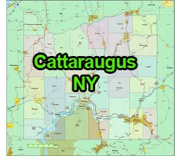
US-NY-Cattaraugus-county-map
shows cities, towns, villages and hamlets on map. Cattaraugus County is a county located in the western part of the state of New York, USA. It is one of the 62 counties in New York.
The county seat of Cattaraugus County is Little Valley, and its largest city is Olean.
Description
Cattaraugus County is a county located in the western part of the state of New York, United States. It is situated in the western region of the state and is known for its natural beauty and outdoor recreational opportunities. Here are some key facts about Cattaraugus County:
- Location: Cattaraugus County is located in the southwestern part of New York State. It is bordered by Chautauqua County to the west, Allegany County to the east, Erie County to the north, and Pennsylvania to the south.
- County Seat: The county seat of Cattaraugus County is the city of Little Valley.
- Geography: The county is characterized by rolling hills, forests, and numerous streams and rivers. It is part of the Appalachian Plateau region and is known for its scenic beauty.
Towns in US-NY-Chattaraugus-county map:
Villages:
Allegany
Ashford
Carrollton
Coldspring
Conewango
Dayton
East Otto
Ellicottville
Farmersville
Franklinville
Freedom
Great Valley
Hinsdale
Humphrey
Ischua
Leon
Little Valley (county seat)
Lyndon
Machias
Mansfield
Napoli
New Albion
Olean
Otto
Perrysburg
Persia
Portville
Randolph
Red House
Salamanca
South Valley
Yorkshire
Allegany
Cattaraugus
Delevan
Ellicottville
Franklinville
Gowanda
Limestone
Little Valley
Portville
South Dayton
Hamlets and Unincorporated Communities:
Cattaraugus County has numerous hamlets and unincorporated communities, including West Valley, East Randolph, Steamburg, East Concord, and many others.

Other New York county map
US-NY-Albany-county-map, Mid Atlantic region counties. 3 state county map
The US-NY-Cattaraugus-county-map file in vector format enable the user organise level of structuring of map.
A vector file (ai, pdf) has flexible tools for displaying elements of maps
- you can discrete or arbitrary scaling map
- performing group operation with selected features
- changing the orders of displaying layers
- switching in/off displaying os any layers
- changing attributes of selected object ( recolour, modify outline thick, transparency, symbols)
- adding or changing features of any items, (i.e. font type)
- copying and moving particular shapes
- merging different shapes (i.e. counties)
- adding, removing cartography symbols
For editing ai, pdf file use the most common Adobe Illustrator (version 10 or higher) or CorelDRAW (version 10 or higher). If you don't have Adobe Illustrator or Corel you can choose
free open source Inkscape - 57 MB -(Windows, Mac, Linux platform ) or Scribus (Windows, Mac, Linux (54 MB)