
US-NY-Albany-county-map is part of a series showing the counties of New York State. Adobe Illustrator file, cs5 version. Digital high resolution printable map. File size: 5 MB. Instant download. 20 layers. Price:$15
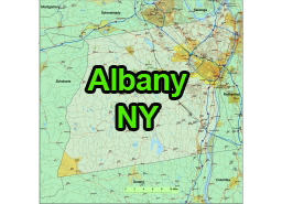
Albany County is located in the state of New York, USA. It is one of the 62 counties in the state and is situated in the eastern part of New York’s Capital Region. Albany is the county seat and the capital city of New York state.
- Main towns
Albany County, New York, is home to a number of towns and villages. Some of the main towns and villages in the county include:
Towns in US-NY-Albany-county-map
- Albany (city): The state capital and the largest city in Albany County.
- Colonie: A suburban town located to the north of Albany.
- Bethlehem: Located to the south of Albany and known for its historic sites and residential areas.
- Guilderland: A town to the west of Albany known for its shopping centers and neighborhoods.
- Cohoes: A city located at the confluence of the Mohawk and Hudson Rivers.
- Green Island: A small town located on an island in the Hudson River.
- Rensselaerville: A rural town in the southwestern part of the county known for its scenic beauty.
- Berne: A town located in the Helderberg Mountains.
- Main vilages
- Altamont: A village within the town of Guilderland.
- Ravena: A village located in the town of Coeymans.
- Voorheesville: A village in the town of New Scotland.
- Menands: A village located just north of Albany.
The US-NY-Albany-county-map file in vector format enable the user organise level of structuring of map.
A vector file (ai, pdf) has flexible tools for displaying elements of maps
- you can discrete or arbitrary scaling map
- performing group operation with selected features
- changing the orders of displaying layers
- switching in/off displaying os any layers
- changing attributes of selected object ( recolour, modify outline thick, transparency, symbols)
- adding or changing features of any items, (i.e. font type)
- copying and moving particular shapes
- merging different shapes (i.e. counties)
- adding, removing cartography symbols
For editing ai, pdf file use the most common Adobe Illustrator (version 10 or higher) or CorelDRAW (version 10 or higher). If you don't have Adobe Illustrator or Corel you can choose
free open source Inkscape - 57 MB -(Windows, Mac, Linux platform ) or Scribus (Windows, Mac, Linux (54 MB)