
Individuelle selectable countries
Plate Carreé rectangular color vector world map same artwork like this only each country has been filled in with colors.
Description
Also known as equirectangular, equidistant cylindrical, simple cylindrical, or rectangular, this projection is very simple to construct because it forms a grid of equal rectangles. Because of its simple calculations, its usage was more common in the past. In this projection, the polar regions are less distorted in scale and area than they are in the Mercator projection.
Projection method
This simple cylindrical projection converts the globe into a Cartesian grid. Each rectangular grid cell has the same size, shape, and area.
Line of contact
Tangent at the equator.
Linear graticules
All meridians and all parallels.
Properties
Shape
Distortion increases as the distance from the standard parallels increases.
Area
Distortion increases as the distance from the standard parallels increases.
Direction
North, south, east, and west directions are accurate. General directions are distorted, except locally along the standard parallels
Distance
The scale is correct along the meridians and the standard parallels.
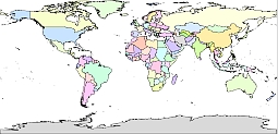
Rectangular color vector world map
Show some love…for your free map
Share on Facebook
144 free world map

The Rectangular color vector world map file in vector format enable the user organise level of structuring of map.
A vector file (ai, pdf) has flexible tools for displaying elements of maps
- you can discrete or arbitrary scaling map
- performing group operation with selected features
- changing the orders of displaying layers
- switching in/off displaying os any layers
- changing attributes of selected object ( recolour, modify outline thick, transparency, symbols)
- adding or changing features of any items, (i.e. font type)
- copying and moving particular shapes
- merging different shapes (i.e. counties)
- adding, removing cartography symbols
For editing ai, pdf file use the most common Adobe Illustrator (version 10 or higher) or CorelDRAW (version 10 or higher). If you don't have Adobe Illustrator or Corel you can choose
free open source Inkscape - 57 MB -(Windows, Mac, Linux platform ) or Scribus (Windows, Mac, Linux (54 MB)