
Individuelle selectable countries
PDF, EPS, JPG, SVG, WMF, AI format (see download link)
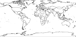
World outline map by country.
Plate carreé projection. This simple cylindrical projection converts the globe into a Cartesian grid. Each rectangular grid cell has the same size, shape, and area. All the graticular intersections are 90°. The traditional Plate Carrée projection uses the equator as the standard parallel. The grid cells are perfect squares. In this projection, the poles are represented as straight lines across the top and bottom of the grid.
Line of contact
Tangent at the equator.
Linear graticules
All meridians and all parallels.
Properties
Shape
Distortion increases as the distance from the standard parallels increases.
Area
Distortion increases as the distance from the standard parallels increases.
World outline map by country
Show some love… for your free map
World outline map by country

The World outline map by country Plate Carreé file in vector format enable the user organise level of structuring of map.
A vector file (ai, pdf) has flexible tools for displaying elements of maps
- you can discrete or arbitrary scaling map
- performing group operation with selected features
- changing the orders of displaying layers
- switching in/off displaying os any layers
- changing attributes of selected object ( recolour, modify outline thick, transparency, symbols)
- adding or changing features of any items, (i.e. font type)
- copying and moving particular shapes
- merging different shapes (i.e. counties)
- adding, removing cartography symbols
For editing ai, pdf file use the most common Adobe Illustrator (version 10 or higher) or CorelDRAW (version 10 or higher). If you don't have Adobe Illustrator or Corel you can choose
free open source Inkscape - 57 MB -(Windows, Mac, Linux platform ) or Scribus (Windows, Mac, Linux (54 MB)