
Are there counties or parishes in Louisiana?
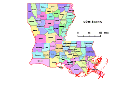
Louisiana is divided into 64 parishes, which serve as the primary political subdivisions of the state. Each parish functions as its own local government and provides various services to its residents, such as law enforcement, road maintenance, and education. In addition to parishes, Louisiana also has municipalities, which are cities and towns with their own local governments. Some of the largest cities in Louisiana include New Orleans, Baton Rouge, and Shreveport.
What is the most important parishes of Louisiana ?
Vector Parishes map of Louisiana has 64 “counties”, each of which plays a unique role in the state’s economy, culture, and history. Some of the most important parishes in Louisiana include:
-
Orleans Parish – home to the city of New Orleans, this parish is a major cultural, economic, and tourist hub for the state and the country.
-
East Baton Rouge Parish – the state capital, Baton Rouge, is located in this parish, which is also a significant center for petrochemical production and manufacturing.
-
Jefferson Parish – located just outside of New Orleans, Jefferson Parish is a major economic engine for the state, with a thriving port and a large petrochemical industry.
-
St. Tammany Parish – located in the North Shore region of the state, this parish is known for its picturesque towns, scenic beauty, and thriving tourism industry.
-
Calcasieu Parish – located in the southwestern part of the state, this parish is a major center for oil and gas production, as well as petrochemical manufacturing.
These parishes, along with others, play a crucial role in shaping Louisiana’s economy, culture, and future.
What can a vector county map of a state be used for?
A vector county map of a state can be used for various purposes, including:
Demographic analysis
Market analysis
Election analysis
Planning and development
Logistics and transportation
Overall, a vector county map of a state is a useful tool for visualizing and analyzing various data and trends, helping to inform decision-making and planning processes
Louisiana zip code map, Colleges and universities in Louisiana. Louisiana State vector road map. West South Central region counties. 4 states county map
- Acadia Parish
- Allen Parish
- Ascension Parish
- Assumption Parish
- Avoyelles Parish
- Beauregard Parish
- Bienville Parish
- Bossier Parish
- Caddo Parish
- Calcasieu Parish
- Caldwell Parish
- Cameron Parish
- Catahoula Parish
- Claiborne Parish
- Concordia Parish
- DeSoto Parish
- East Baton Rouge Parish
- East Carroll Parish
- source: https://www.louisiana.gov/local-louisiana/
The Parishes map of Louisiana colored. file in vector format enable the user organise level of structuring of map.
A vector file (ai, pdf) has flexible tools for displaying elements of maps
- you can discrete or arbitrary scaling map
- performing group operation with selected features
- changing the orders of displaying layers
- switching in/off displaying os any layers
- changing attributes of selected object ( recolour, modify outline thick, transparency, symbols)
- adding or changing features of any items, (i.e. font type)
- copying and moving particular shapes
- merging different shapes (i.e. counties)
- adding, removing cartography symbols
For editing ai, pdf file use the most common Adobe Illustrator (version 10 or higher) or CorelDRAW (version 10 or higher). If you don't have Adobe Illustrator or Corel you can choose
free open source Inkscape - 57 MB -(Windows, Mac, Linux platform ) or Scribus (Windows, Mac, Linux (54 MB)