
Idaho map with jpg image size: 2816×4096 px at 72 ppi

Introducing the Idaho Map with JPG Image – a comprehensive and visually captivating representation of the Gem State. This product offers a multitude of features and benefits that will enhance your understanding of Idaho’s geography and aid in various applications.
Features and Benefits:
1.
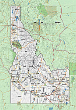
Large JPG Background:
The Idaho map comes with a high-resolution JPG image, providing a detailed and visually appealing backdrop of the state. This ensures clarity and ease of navigation when exploring the various regions and landmarks of Idaho.
County Borders and Shapes: With separate layers dedicated to county borders and shapes, this map allows for a comprehensive understanding of Idaho’s county divisions. Whether you’re conducting research, planning a trip, or analyzing specific areas, these layers provide valuable information at a glance.
County Names: The inclusion of county names on separate layers further enhances the usability of the Idaho map. Instantly identify and locate specific counties with ease, making it an invaluable tool for educators, researchers, and anyone interested in the state’s regional demarcations.
Main Roads and Cities: The map prominently displays the main roads and cities of Idaho, ensuring that key transportation routes and urban centers are easily identifiable. Whether you’re planning a road trip, studying population centers, or analyzing transportation networks, this feature proves to be incredibly useful.
Waterbodies: The Idaho map also incorporates waterbodies such as rivers, lakes, and reservoirs. This inclusion provides valuable insights into Idaho’s natural resources, recreational areas, and environmental features.
In summary, the Idaho Map with JPG Image offers a comprehensive and visually engaging depiction of the state. With its large JPG background, separate layers for county borders, shapes, and names, as well as clear markings for main roads, cities, and waterbodies, this map is a valuable asset for a wide range of purposes. Whether you’re an educator, researcher, traveler, or simply curious about Idaho, this product will undoubtedly enhance your understanding and appreciation of the Gem State.
Other Idaho maps:Idaho zip code map, Idaho 3 digit zip code and county map Idaho elevation map Idaho State Vector Road Map
The Idaho map with jpg image. 17 MB file in vector format enable the user organise level of structuring of map.
A vector file (ai, pdf) has flexible tools for displaying elements of maps
- you can discrete or arbitrary scaling map
- performing group operation with selected features
- changing the orders of displaying layers
- switching in/off displaying os any layers
- changing attributes of selected object ( recolour, modify outline thick, transparency, symbols)
- adding or changing features of any items, (i.e. font type)
- copying and moving particular shapes
- merging different shapes (i.e. counties)
- adding, removing cartography symbols
For editing ai, pdf file use the most common Adobe Illustrator (version 10 or higher) or CorelDRAW (version 10 or higher). If you don't have Adobe Illustrator or Corel you can choose
free open source Inkscape - 57 MB -(Windows, Mac, Linux platform ) or Scribus (Windows, Mac, Linux (54 MB)