
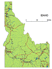
Idaho State vector road map is an essential tool for designers and anyone looking to explore the beauty of Idaho. This map showcases the main roads, road signs, and important settlements, allowing you to easily navigate through the state. With its comprehensive illustrator file, it is the most intricate and detailed map available on the webshop. Whether you want to complement it with your own color scheme or highlight specific points of interest, this map gives you the flexibility to customize it to your liking.
 |
Layers-county name black of state Idaho |
Counties on Idaho state vector road map
Metro Areas on Idaho state vector road map
Major Cities on Idaho state vector road map
Idaho Interstates:
North-South interstates include: Interstate 15. East-West interstates include: Interstate 84, Interstate 86 and Interstate 90.
Idaho Routes:
US Highways and State Routes include: Route 12, Route 20, Route 26, Route 30, Route 89, Route 91, Route 93 and Route 95.

Idaho Highways, State Roads, Rivers, Main Cities, Locations, Counties.printable Map.
The Preview of Idaho State vector road map file in vector format enable the user organise level of structuring of map.
A vector file (ai, pdf) has flexible tools for displaying elements of maps
- you can discrete or arbitrary scaling map
- performing group operation with selected features
- changing the orders of displaying layers
- switching in/off displaying os any layers
- changing attributes of selected object ( recolour, modify outline thick, transparency, symbols)
- adding or changing features of any items, (i.e. font type)
- copying and moving particular shapes
- merging different shapes (i.e. counties)
- adding, removing cartography symbols
For editing ai, pdf file use the most common Adobe Illustrator (version 10 or higher) or CorelDRAW (version 10 or higher). If you don't have Adobe Illustrator or Corel you can choose
free open source Inkscape - 57 MB -(Windows, Mac, Linux platform ) or Scribus (Windows, Mac, Linux (54 MB)