
Alabama 3 digit zip code vector map map available in three file format: AI, PDF, SVG.
How many layers does this vector file contain?
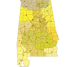
4 layers make up the image. the county and 3-digit zip code map are superimposed. Make one of the layers semi-transparent and it will be easy to explore borders.
Each 5-digit ZIP code is comprised of a three-digit “ZIP code prefix” that narrows the geographical region, and a two-digit “ZIP code suffix” that further narrows down the location. Alabama 3 digit zip code vector mapThe first three digits of a ZIP code make up the “ZIP code prefix,” which can be grouped into wider geographical areas referred to as “ZIP code groups” or “ZIP code areas.” These groups are commonly represented by the first three digits of a ZIP code, and can be used to approximate larger geographical regions.
What is the difference between a three- and five-digit zip code?
In the United States, zip codes are five-digit numbers used to identify a specific geographic location. However, some organizations and businesses may use a three-digit version of the zip code, which represents a broader geographic region or a group of zip codes.
Here is a list of the three-digit zip code areas in Alabama, along with the corresponding cities and counties:
350 – Birmingham, Jefferson County 356 – Huntsville, Madison County 360 – Montgomery, Montgomery County 369 – Selma, Dallas County 368 – Auburn, Lee County 366 – Mobile, Mobile County 365 – Daphne, Baldwin County 367 – Tuskegee, Macon County
Please note that three-digit zip codes are not an official designation by the United States Postal Service (USPS) and are not universally recognized.

The Alabama 3 digit zip code vector map file in vector format enable the user organise level of structuring of map.
A vector file (ai, pdf) has flexible tools for displaying elements of maps
- you can discrete or arbitrary scaling map
- performing group operation with selected features
- changing the orders of displaying layers
- switching in/off displaying os any layers
- changing attributes of selected object ( recolour, modify outline thick, transparency, symbols)
- adding or changing features of any items, (i.e. font type)
- copying and moving particular shapes
- merging different shapes (i.e. counties)
- adding, removing cartography symbols
For editing ai, pdf file use the most common Adobe Illustrator (version 10 or higher) or CorelDRAW (version 10 or higher). If you don't have Adobe Illustrator or Corel you can choose
free open source Inkscape - 57 MB -(Windows, Mac, Linux platform ) or Scribus (Windows, Mac, Linux (54 MB)