
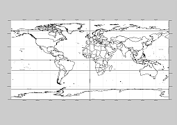
WGS1984 projection
The most popular world outline map with graticules. Illustrator file has 3 layers.High quality image for creative projects. Instanat Free for download. (any email adress) Global map, digital map, world vector map. You don’t have to buy it, just download it and pay. It costs $1
Layers: graticules, county outlines, geogrids.
PDF, EPS, JPG, SVG, WMF, AI format (see download link)

Show some love… for your free map
World outline with graticules
The World outline map with graticules. file in vector format enable the user organise level of structuring of map.
A vector file (ai, pdf) has flexible tools for displaying elements of maps
- you can discrete or arbitrary scaling map
- performing group operation with selected features
- changing the orders of displaying layers
- switching in/off displaying os any layers
- changing attributes of selected object ( recolour, modify outline thick, transparency, symbols)
- adding or changing features of any items, (i.e. font type)
- copying and moving particular shapes
- merging different shapes (i.e. counties)
- adding, removing cartography symbols
For editing ai, pdf file use the most common Adobe Illustrator (version 10 or higher) or CorelDRAW (version 10 or higher). If you don't have Adobe Illustrator or Corel you can choose
free open source Inkscape - 57 MB -(Windows, Mac, Linux platform ) or Scribus (Windows, Mac, Linux (54 MB)