
Tropic of Cancer, Equatorial, longitude and latitude
vector world map Gall projection
Description
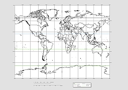
Vector world map Gall projection, presented by James Gall in 1855, is a cylindrical projection. It is a cylindrical projection with two standard parallels at latitudes 45° N and S.
Projection method
A cylindrical stereographic projection based on two standard parallels at 45° N and S.
Linear graticules
All meridians and parallels.
Free Gall projection vector world map
Properties
Shape
Shapes are true at latitudes 45° N and S. Distortion slowly increases away from these latitudes and becomes severe at the poles.
Properties
Area
Area is true at latitudes 45° N and S. Distortion slowly increases away from these latitudes and becomes severe at the poles.
Direction
Locally correct at latitudes 45° N and S. Generally distorted elsewhere.
World map. Gall projection with geography lines

The World map. Gall projection with geography lines file in vector format enable the user organise level of structuring of map.
A vector file (ai, pdf) has flexible tools for displaying elements of maps
- you can discrete or arbitrary scaling map
- performing group operation with selected features
- changing the orders of displaying layers
- switching in/off displaying os any layers
- changing attributes of selected object ( recolour, modify outline thick, transparency, symbols)
- adding or changing features of any items, (i.e. font type)
- copying and moving particular shapes
- merging different shapes (i.e. counties)
- adding, removing cartography symbols
For editing ai, pdf file use the most common Adobe Illustrator (version 10 or higher) or CorelDRAW (version 10 or higher). If you don't have Adobe Illustrator or Corel you can choose
free open source Inkscape - 57 MB -(Windows, Mac, Linux platform ) or Scribus (Windows, Mac, Linux (54 MB)