
US-NY-Suffolk-county-map vector map. Adobe Illustrator file. 4,5 MB. Cities, rivers, roads, lakes
etc. Data source: U.S. Geological Survey

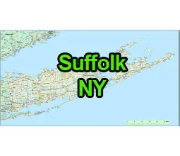
Location:
- Region: Long Island, Southeastern New York
- Adjacent Counties:
- Nassau County (to the west)
- Queens County (to the west, separated by water)
- Connecticut (to the north, across the Long Island Sound)
- Atlantic Ocean (to the south)
County Seat:
The county seat is Riverhead.
Cities, Towns, and Villages:
- Cities: There are no cities in Suffolk County.
- Towns: Babylon, Brookhaven (largest town by population), East Hampton, Huntington, Islip, Riverhead, Shelter Island, Smithtown, Southampton, Southold
- Villages: There are numerous villages within the towns, including Patchogue, Port Jefferson, Sag Harbor, Westhampton Beach, Greenport, and many more.
Attractions on US-NY-Suffolk-county-map
- The Hamptons: A collection of affluent villages and hamlets known for their beaches, luxury homes, and art scene.
- Fire Island: A barrier island off the southern coast known for its beaches, nightlife, and nature preserves.
- Montauk Point Lighthouse: The oldest lighthouse in New York State, located at the eastern tip of Long Island.
- Vineyards and Wineries: The North Fork of Long Island is dotted with vineyards and wineries, offering tours and tastings.
- Atlantis Marine World Aquarium: Located in Riverhead, this aquarium features marine life exhibits and educational programs.
The US-NY-Suffolk-county-map file in vector format enable the user organise level of structuring of map.
A vector file (ai, pdf) has flexible tools for displaying elements of maps
- you can discrete or arbitrary scaling map
- performing group operation with selected features
- changing the orders of displaying layers
- switching in/off displaying os any layers
- changing attributes of selected object ( recolour, modify outline thick, transparency, symbols)
- adding or changing features of any items, (i.e. font type)
- copying and moving particular shapes
- merging different shapes (i.e. counties)
- adding, removing cartography symbols
For editing ai, pdf file use the most common Adobe Illustrator (version 10 or higher) or CorelDRAW (version 10 or higher). If you don't have Adobe Illustrator or Corel you can choose
free open source Inkscape - 57 MB -(Windows, Mac, Linux platform ) or Scribus (Windows, Mac, Linux (54 MB)