
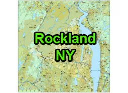
US-NY-Rockland-county-map vector map. Adobe Illustrator file. 5,2 MB. Cities, rivers, roads, lakes
etc. Data source: U.S. Geological Survey
Location:
- Region: Lower Hudson Valley, Southern New York
- Adjacent Counties:
- Orange County (to the north)
- Westchester County (to the east)
- Bergen County, New Jersey (to the south)
- Passaic County, New Jersey (to the southwest)
County Seat:
The county seat is New City.
Cities, Towns, and Villages:
- Cities: There are no cities in Rockland County.
- Towns: Clarkstown (largest town by population), Ramapo, Orangetown, Haverstraw, Stony Point
- Villages: Suffern, Nyack, Spring Valley, Piermont, Haverstraw, South Nyack, Upper Nyack, Grand View-on-Hudson, Pomona, Wesley Hills, New Hempstead, Montebello, Airmont, Chestnut Ridge, Hillburn, Kaser, New Square, Sloatsburg, and more.

Attractions:
- Nyack: A charming village known for its artistic community, antique shops, and dining.
- Bear Mountain State Park: A large state park offering hiking, picnicking, swimming, and stunning views of the Hudson River.
- Rockland Lake State Park: Features trails, a lake for swimming and boating, and picnic areas.
- Hudson River Towns: Several towns along the Hudson River offer historic sites, art galleries, and waterfront dining.
The US-NY-Rockland-county-map file in vector format enable the user organise level of structuring of map.
A vector file (ai, pdf) has flexible tools for displaying elements of maps
- you can discrete or arbitrary scaling map
- performing group operation with selected features
- changing the orders of displaying layers
- switching in/off displaying os any layers
- changing attributes of selected object ( recolour, modify outline thick, transparency, symbols)
- adding or changing features of any items, (i.e. font type)
- copying and moving particular shapes
- merging different shapes (i.e. counties)
- adding, removing cartography symbols
For editing ai, pdf file use the most common Adobe Illustrator (version 10 or higher) or CorelDRAW (version 10 or higher). If you don't have Adobe Illustrator or Corel you can choose
free open source Inkscape - 57 MB -(Windows, Mac, Linux platform ) or Scribus (Windows, Mac, Linux (54 MB)