
US-NY-Genesee-county-map Vector map. Adobe Illustrator file. File size: 1.6 MB. Cities, rivers, roads, lakes etc. Data source: U.S. Geological Survey
Location:
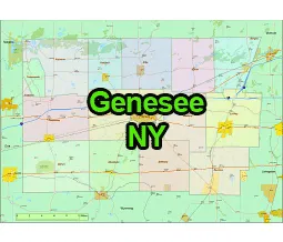
- Region: Western New York
- Adjacent Counties: Genesee County is bordered by Monroe County to the west, Orleans County to the north, Wyoming County to the east, and Livingston County to the south.
- Distance from NYC: Genesee County is approximately 300 miles northwest of New York City.
Geography:
- Land Area: Genesee County covers an area of 495 square miles.
- Terrain: The county’s landscape is relatively flat, with some rolling hills. It is part of the Great Lakes Plain, which is characterized by fertile soil.
- Waterways: The Tonawanda Creek flows through the county, along with various other smaller streams.
The US-NY-Genesee-county-map file in vector format enable the user organise level of structuring of map.
A vector file (ai, pdf) has flexible tools for displaying elements of maps
- you can discrete or arbitrary scaling map
- performing group operation with selected features
- changing the orders of displaying layers
- switching in/off displaying os any layers
- changing attributes of selected object ( recolour, modify outline thick, transparency, symbols)
- adding or changing features of any items, (i.e. font type)
- copying and moving particular shapes
- merging different shapes (i.e. counties)
- adding, removing cartography symbols
For editing ai, pdf file use the most common Adobe Illustrator (version 10 or higher) or CorelDRAW (version 10 or higher). If you don't have Adobe Illustrator or Corel you can choose
free open source Inkscape - 57 MB -(Windows, Mac, Linux platform ) or Scribus (Windows, Mac, Linux (54 MB)