
US-NY-Chautauqua-county-map Adobe Illustrator file.
Geography:
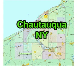
- Location: Chautauqua County is situated in the far western part of New York State, bordering Lake Erie to the north.
- Adjacent Counties: It is bordered by Erie County to the east, Cattaraugus County to the southeast, and Warren County in Pennsylvania to the southwest.
- Size: The county has a total area of 1,500 square miles (3,900 km2), making it the third-largest county in New York by land area.
- Topography: The terrain is diverse, ranging from the shores of Lake Erie to rolling hills and agricultural land further inland.
Cities:
- Jamestown – The largest city in Chautauqua County and the county seat. It is known for being the birthplace of Lucille Ball and for the Chautauqua Institution.
Towns:
- Dunkirk – A city located on the shores of Lake Erie, known for its historical lighthouse and maritime history.
- Fredonia – A village within the Town of Pomfret, home to the State University of New York at Fredonia.
- Westfield – A town with a village of the same name, located near Lake Erie. It is known for its wineries and historic attractions.
- Chautauqua – A town that surrounds the Chautauqua Institution, a historic education center and cultural hub.
- Mayville – The county seat of Chautauqua County prior to 1974, located near Chautauqua Lake.
- Sheridan – A town in the northern part of the county, known for its rural character and agricultural activities.
- Pomfret – A town that includes the village of Fredonia and is known for its historic architecture.
- Portland – A town located on Lake Erie, known for its vineyards and agricultural heritage.
- Ellicott – A town that includes the city of Jamestown, known for its historical significance in the region.
- Ripley – A town located in the northern part of the county, known for its vineyards and scenic beauty.
The US-NY-Chautauqua-county-map file in vector format enable the user organise level of structuring of map.
A vector file (ai, pdf) has flexible tools for displaying elements of maps
- you can discrete or arbitrary scaling map
- performing group operation with selected features
- changing the orders of displaying layers
- switching in/off displaying os any layers
- changing attributes of selected object ( recolour, modify outline thick, transparency, symbols)
- adding or changing features of any items, (i.e. font type)
- copying and moving particular shapes
- merging different shapes (i.e. counties)
- adding, removing cartography symbols
For editing ai, pdf file use the most common Adobe Illustrator (version 10 or higher) or CorelDRAW (version 10 or higher). If you don't have Adobe Illustrator or Corel you can choose
free open source Inkscape - 57 MB -(Windows, Mac, Linux platform ) or Scribus (Windows, Mac, Linux (54 MB)