
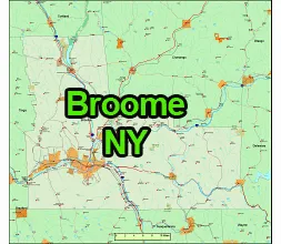
US-NY-Broome-county-map is an editable Adobe Illustrator printable map on 20 layers. All inhabited settlements, Interstate higways -81, 88 – and state roads can be found on the map.
Broome County is a county located in the southern tier of the U.S. state of New York.
- County Seat:
- The county seat of Broome County is Binghamton, which is also the largest city in the county.
- Location:
- Broome County is situated in the southern part of New York State, near the border with Pennsylvania. It is part of the Southern Tier region of New York.
- Population:
- As of my knowledge cutoff date in September 2021, Broome County had a population of over 190,000 people. Please note that population figures may have changed since then.
- Economy:
- Historically, the economy of Broome County has been closely tied to manufacturing and technology, but it has diversified over the years. The presence of Binghamton University and several healthcare institutions also contributes to the local economy.
- US-NY-Broome-county-map
- Attractions:
- Broome County offers a variety of recreational and cultural attractions. The region is known for its natural beauty, including parks and outdoor activities. The Roberson Museum and Science Center, Binghamton Zoo at Ross Park, and Kopernik Observatory & Science Center are some of the cultural and educational attractions in the county.
- Educational Institutions:
- Binghamton University, a part of the State University of New York (SUNY) system, is a major educational institution in Broome County.
- History:
- Broome County was named after John Broome, who was a lieutenant governor of New York and a prominent figure in the state’s early history. The county was established in 1806.
- Transportation:
- The area is served by several major highways, including Interstate 81 and State Route 17 (commonly known as the Southern Tier Expressway). The Greater Binghamton Airport provides air travel options.

The US-NY-Broome-county-map file in vector format enable the user organise level of structuring of map.
A vector file (ai, pdf) has flexible tools for displaying elements of maps
- you can discrete or arbitrary scaling map
- performing group operation with selected features
- changing the orders of displaying layers
- switching in/off displaying os any layers
- changing attributes of selected object ( recolour, modify outline thick, transparency, symbols)
- adding or changing features of any items, (i.e. font type)
- copying and moving particular shapes
- merging different shapes (i.e. counties)
- adding, removing cartography symbols
For editing ai, pdf file use the most common Adobe Illustrator (version 10 or higher) or CorelDRAW (version 10 or higher). If you don't have Adobe Illustrator or Corel you can choose
free open source Inkscape - 57 MB -(Windows, Mac, Linux platform ) or Scribus (Windows, Mac, Linux (54 MB)