
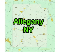
US-NY-Allegany county map is a Print quality Adobe Illustrator File.

Allegany County is a county located in the state of New York, USA. It is in the western part of the state and is part of the Southern Tier region. The county seat is Belmont, and the county is named after the Allegheny River.
Towns
Alfred, Allen, Alma, Almond, Amity, Andover, Angelica, Belfast, Birdsall, Bolivar, Burns, Caneadea, Centerville, Clarksville, Friendship, Genesee, Granger, Grove, Hume, Independence, New Hudson, Rushford, Scio, Ward, Willing, Wirt
US-NY-Allegany county map
Villages
Alfred, Andover, Angelica, Almond, Belmont (County Seat) , Bolivar, Canaseraga, Cuba, Fillmor, Friendship
Richburg, Wellsville
Hamlets and Unincorporated Communities:
Allegany County also has various hamlets and unincorporated communities, including Black Creek, Nile, Shongo, Allentown, Birdsall, Belfast, Caneadea, Houghton, Rushford, Swain, Whitesville, and many more.

The US-NY-Allegany county map file in vector format enable the user organise level of structuring of map.
A vector file (ai, pdf) has flexible tools for displaying elements of maps
- you can discrete or arbitrary scaling map
- performing group operation with selected features
- changing the orders of displaying layers
- switching in/off displaying os any layers
- changing attributes of selected object ( recolour, modify outline thick, transparency, symbols)
- adding or changing features of any items, (i.e. font type)
- copying and moving particular shapes
- merging different shapes (i.e. counties)
- adding, removing cartography symbols
For editing ai, pdf file use the most common Adobe Illustrator (version 10 or higher) or CorelDRAW (version 10 or higher). If you don't have Adobe Illustrator or Corel you can choose
free open source Inkscape - 57 MB -(Windows, Mac, Linux platform ) or Scribus (Windows, Mac, Linux (54 MB)