
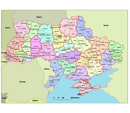
The purpose of the file is to process the administrative division of Ukraine in a clearly visible manner, while at the same time enabling editing, highlighting, and redrawing. Orientation is aided by the display of neighboring countries and the scale with which we can easily assess the size of the areas.
The first tier consists of 27 subdivisions, of which there are 24 oblasts, one autonomous republic (Crimea) and 2 cities with special status (Kyiv and Sevastopol). The second tier includes 136 raions. Third level of administrative division ar city councils and the fourth level rural counsils.
There is a transliteration on the map (romanized Ukrainian).
example
By turning layers on and off in the illustrator file, any part can be displayed independently.
This large amount of text was created exclusively for Google search, and that’s why it’s so long.

Ukraine Map 24 Oblast And 136 Raion Map
The Ukraine first and second administrative vector map file in vector format enable the user organise level of structuring of map.
A vector file (ai, pdf) has flexible tools for displaying elements of maps
- you can discrete or arbitrary scaling map
- performing group operation with selected features
- changing the orders of displaying layers
- switching in/off displaying os any layers
- changing attributes of selected object ( recolour, modify outline thick, transparency, symbols)
- adding or changing features of any items, (i.e. font type)
- copying and moving particular shapes
- merging different shapes (i.e. counties)
- adding, removing cartography symbols
For editing ai, pdf file use the most common Adobe Illustrator (version 10 or higher) or CorelDRAW (version 10 or higher). If you don't have Adobe Illustrator or Corel you can choose
free open source Inkscape - 57 MB -(Windows, Mac, Linux platform ) or Scribus (Windows, Mac, Linux (54 MB)