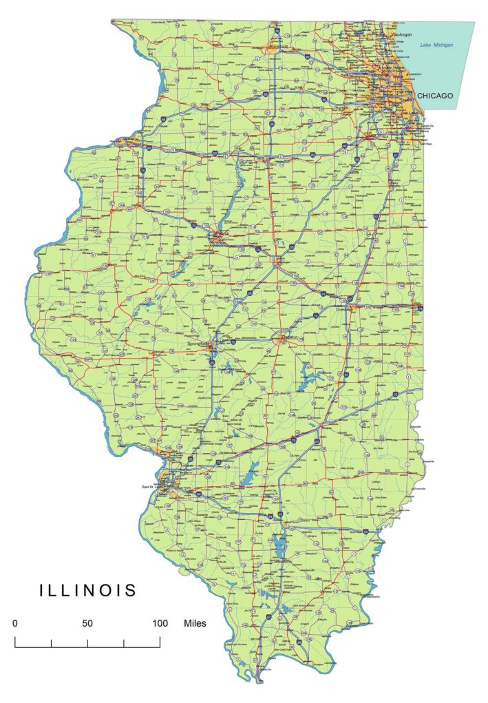
Illinois State vector road map.ai, pdf, 300 dpi jpg

Your-Vector-Maps.com Illinois State vector road map.ai, pdf, 300 dpi jpg

Illinois State National and State Highways map

California vector map-layers
Layers
-county name black of state Illinois
-country name white of state Illinois
-names of rivers, lakes of state Illinois
-capital sign of state Illinois
-highway symbols of state Illinois
-road signs state Illinois
-city names of state Illinois
-highway – lines of state Illinois
-A road lines of state Illinois
-B road lines of state Illinois
-C road lines of state Illinois
-lakes of state Illinois
-rivers of state Illinois
-urban areas of state Illinois
-state border os state Illinois
-counties of state  Illinois
Major Counties:
Champaign, Cook, DuPage, Kane, Lake, Madison, McHenry, McLean, Peoria, Rock Island, Sangamon, St. Clair, Tazewell, Will, Winnebago

Counties:
Adams,   Alexander,    Bond,    Boone,    Brown,    Bureau,    Calhoun,    Carroll,    Cass,    Champaign,    Christian,    Clark,    Clay,    Clinton,    Coles, Cook,    Crawford,    Cumberland,    De Witt,   DeKalb,    Douglas,    DuPage,    Edgar,    Edwards, Effingham,   Fayette,   Ford,    Franklin,   Fulton, Gallatin,    Greene,    Grundy,    Hamilton,    Hancock,   Hardin,    Henderson,    Henry,    Iroquois,    Jackson,    Jasper,    Jefferson,    Jersey,    Jo Daviess,    Johnson,    Kane,    Kankakee,    Kendall,   Knox,    LaSalle,    Lake,    Lawrence,    Lee,    Livingston,    Logan,    Macon,    Macoupin, Madison,    Marion,    Marshall,    Mason,    Massac,    McDonough,    McHenry,    McLean,    Menard,   Mercer,   Monroe,   Montgomery,    Morgan, Moultrie,    Ogle,    Peoria,    Perry,    Piatt,    Pike,    Pope,    Pulaski,    Putnam,    Randolph,    Richland,    Rock Island,    Saline,   Sangamon, Schuyler,    Scott,    Shelby,    St. Clair,    Stark,    Stephenson,   Tazewell,    Union,    Vermilion,    Wabash,    Warren,    Washington,   Wayne,    White,    Whiteside,    Will,    Williamson,    Winnebago,    Woodford

Major Cities:
Aurora,     Belleville,     Berwyn,     Bloomington,     Champaign,    Chicago,    Crystal Lake,    DeKalb,     Decatur,     Des Plaines,    Elgin,    Elmhurst, Evanston,    Joliet,    Moline,    Naperville,     Park Ridge,    Peoria,    Quincy,    Rock Island,     Rockford,     Springfield,    Urbana,    Waukegan,    Wheaton

Major Towns:
Illinois Interstates:
North-South interstates include: Interstate 39, Interstate 55 and Interstate 57. East-West interstates include: Interstate 24, Interstate 64, Interstate 70, Interstate 72, Interstate 74, Interstate 80, Interstate 88, Interstate 90, Interstate 94 and Interstate 294.Illinois Routes:
US Highways and State Routes include: Route 1, Route 17, Route 19, Route 23, Route 25, Route 27, Route 27A, Route 29, Route 41, Route 76, Route 78, Route 80, Route 82, Route 84, Route 129, Route 221, Route 278, route 280, Route 301, Route 319, Route 341, Route 378 and Route 441.
Illinois roads and cities, water bodies, state/county/country boundaries, road lines, map symbols, map scale.

Illinois highways, state roads, rivers, main cities, locations, counties.Printable map.

Top