
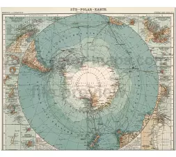
South Pole map 1911 – from Stieler’ Hand Atlas. German-language map Süd Polar Karte. World area: Antarctica
File type and dimension
Dimension: 9152x7761px at 72 ppi
File size: 42 MB JPG
Detailed, colored, with 14 map inset.
Map Insets
West Antarktis, Süd Georgien, Deception Inseln, Moltke Hafen, Auckland Inseln, Chatman Inseln, Bouvet Inseln, Macquarie Inseln, Campbell Inseln, Victoria Land, Neu Amsterdam & St.Paul, Prinz Eduard Inseln, Grozet Inseln, Kergulen Inseln


Other Globe maps
20 Globes from Space Africa continent map America continent map Asia continent map Europe continent map
The South Pole map 1911 file in vector format enable the user organise level of structuring of map.
A vector file (ai, pdf) has flexible tools for displaying elements of maps
- you can discrete or arbitrary scaling map
- performing group operation with selected features
- changing the orders of displaying layers
- switching in/off displaying os any layers
- changing attributes of selected object ( recolour, modify outline thick, transparency, symbols)
- adding or changing features of any items, (i.e. font type)
- copying and moving particular shapes
- merging different shapes (i.e. counties)
- adding, removing cartography symbols
For editing ai, pdf file use the most common Adobe Illustrator (version 10 or higher) or CorelDRAW (version 10 or higher). If you don't have Adobe Illustrator or Corel you can choose
free open source Inkscape - 57 MB -(Windows, Mac, Linux platform ) or Scribus (Windows, Mac, Linux (54 MB)