
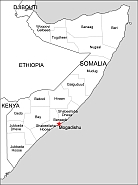
Somalia as country of Horn of Africa.
Location:
Eastern Africa, bordering the Gulf of Aden and the Indian Ocean, east of Ethiopia
Area:
total: 637,657 sq km
land: 627,337 sq km
water: 10,320 sq km
country comparison to the world: 44
Area – comparative:
almost five times the size of Alabama; slightly smaller than Texas
Land boundaries:
total: 2,385 km
border countries (3): Djibouti 61 km, Ethiopia 1,640 km, Kenya 684 km
Coastline:
3,025 km
Povinces of Somalia: Woqooyi Galbeed, Togdheer, Sanaag, Bari, Nugaal, Mudug, Galguduud, Hirran, Bakool. Capital: Mogadishu.
The Somalia free eps vector map file in vector format enable the user organise level of structuring of map.
A vector file (ai, pdf) has flexible tools for displaying elements of maps
- you can discrete or arbitrary scaling map
- performing group operation with selected features
- changing the orders of displaying layers
- switching in/off displaying os any layers
- changing attributes of selected object ( recolour, modify outline thick, transparency, symbols)
- adding or changing features of any items, (i.e. font type)
- copying and moving particular shapes
- merging different shapes (i.e. counties)
- adding, removing cartography symbols
For editing ai, pdf file use the most common Adobe Illustrator (version 10 or higher) or CorelDRAW (version 10 or higher). If you don't have Adobe Illustrator or Corel you can choose
free open source Inkscape - 57 MB -(Windows, Mac, Linux platform ) or Scribus (Windows, Mac, Linux (54 MB)