
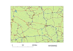
A map of Wyoming includes interstates, US Highways and State routes
Wyoming vector road map
JPG: 3780 x 3189 pixel at 300 dpi. 6 MB
Map shows cca. 150 City name as Jackson, Thermopolis, Riverton, Casper, Worland, Rock Springs.
| Layers _county name red of state Wyoming _country name white of state Wyoming _names of rivers, lakes of state Wyoming _capital sign of state Wyoming _highway symbols of state Wyoming _road singns state Wyoming _city names of state Wyoming _highway – lines of state Wyoming _A road lines of state Wyoming _B road lines of state Wyoming _C road lines of state Wyoming _lakes of state Wyoming _rivers of state Wyoming _urban areas of state Wyoming _state border os state Wyoming _counties of state Wyoming |
Other Wyoming map: WY 5-digit-zip-code map
The Wyoming vector road map. file in vector format enable the user organise level of structuring of map.
A vector file (ai, pdf) has flexible tools for displaying elements of maps
- you can discrete or arbitrary scaling map
- performing group operation with selected features
- changing the orders of displaying layers
- switching in/off displaying os any layers
- changing attributes of selected object ( recolour, modify outline thick, transparency, symbols)
- adding or changing features of any items, (i.e. font type)
- copying and moving particular shapes
- merging different shapes (i.e. counties)
- adding, removing cartography symbols
For editing ai, pdf file use the most common Adobe Illustrator (version 10 or higher) or CorelDRAW (version 10 or higher). If you don't have Adobe Illustrator or Corel you can choose
free open source Inkscape - 57 MB -(Windows, Mac, Linux platform ) or Scribus (Windows, Mac, Linux (54 MB)