
New Mexico State vector road map structure
 |
|
||||||||||||||||||||||||
For designers
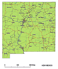
The New Mexico state vector road map is an essential tool for designers and anyone looking to explore the beauty of New Mexico. This map showcases the main roads, road signs, and important settlements, allowing you to easily navigate through the state. With its comprehensive illustrator file, it is the most intricate and detailed map available on the webshop. Whether you want to complement it with your own color scheme or highlight specific points of interest, this map gives you the flexibility to customize it to your liking.
Available
New Mexico State vector road map
Adobe Illustrator, PDF, and high-resolution JPG formats, it provides the versatility you need for any project. Get ready to embark on a journey and discover all that New Mexico has to offer with this fantastic map.

Other New Mexico maps: New Mexico state subdivision map, County seats of NM, New Mexico State zip codes,5 digit editable zip code map of New Mexico
The New Mexico State vector road map. file in vector format enable the user organise level of structuring of map.
A vector file (ai, pdf) has flexible tools for displaying elements of maps
- you can discrete or arbitrary scaling map
- performing group operation with selected features
- changing the orders of displaying layers
- switching in/off displaying os any layers
- changing attributes of selected object ( recolour, modify outline thick, transparency, symbols)
- adding or changing features of any items, (i.e. font type)
- copying and moving particular shapes
- merging different shapes (i.e. counties)
- adding, removing cartography symbols
For editing ai, pdf file use the most common Adobe Illustrator (version 10 or higher) or CorelDRAW (version 10 or higher). If you don't have Adobe Illustrator or Corel you can choose
free open source Inkscape - 57 MB -(Windows, Mac, Linux platform ) or Scribus (Windows, Mac, Linux (54 MB)