
Kentucky State vector road map
 |
Layers-county name black of state Kentucky |

Kentucky Highways, State Roads, Rivers, Main Cities, Locations, Counties.printable Map.
Kentucky highways
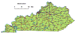
I-24: Interstate 24 runs from the western border of Kentucky, near Paducah, through the southwestern part of the state, including cities like Paducah and Hopkinsville. It continues eastward into Tennessee.
I-64: Interstate 64 is an east-west highway that enters Kentucky from Indiana in the west and passes through cities like Louisville, Frankfort, and Lexington before continuing into West Virginia.
I-65: Interstate 65 is a major north-south route in Kentucky, connecting Louisville to cities like Elizabethtown, Bowling Green, and Nashville, Tennessee. It extends further north into Indiana and south into Tennessee and Alabama.
I-69: I-69 is a relatively new addition to Kentucky’s interstate system, extending from the Tennessee border near Fulton northward to Henderson, where it connects to I-64. This highway will eventually continue north into Indiana.
I-71: Interstate 71 is primarily located in northern Kentucky, connecting Louisville to cities like Carrollton and Cincinnati, Ohio. It continues northward into Ohio.
I-75: Interstate 75 runs north-south through the eastern part of Kentucky, connecting cities like Covington, Lexington, and Richmond. It extends into Ohio to the north and Tennessee to the south.
I-265: This is a beltway around Louisville, which helps alleviate traffic congestion in the city and connects to other major interstates, such as I-64 and I-65.
The Preview of Kentucky State vector road map. file in vector format enable the user organise level of structuring of map.
A vector file (ai, pdf) has flexible tools for displaying elements of maps
- you can discrete or arbitrary scaling map
- performing group operation with selected features
- changing the orders of displaying layers
- switching in/off displaying os any layers
- changing attributes of selected object ( recolour, modify outline thick, transparency, symbols)
- adding or changing features of any items, (i.e. font type)
- copying and moving particular shapes
- merging different shapes (i.e. counties)
- adding, removing cartography symbols
For editing ai, pdf file use the most common Adobe Illustrator (version 10 or higher) or CorelDRAW (version 10 or higher). If you don't have Adobe Illustrator or Corel you can choose
free open source Inkscape - 57 MB -(Windows, Mac, Linux platform ) or Scribus (Windows, Mac, Linux (54 MB)