
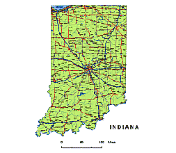
The Indiana State Vector Road Map
is a printable map that offers a wealth of features and benefits. It includes detailed information such as settlements, roads, rivers, state highways, county boundaries, and statewide borders. With a scalable bar for maps, it provides flexibility for various uses.
One limitation of this map is that it is editable only in Adobe Illustrator and PDF formats. However, it compensates for this drawback by offering roads shields and the ability to recolor the map without losing any quality. The map is also well-layered, making it easy to navigate and customize.
Whether you’re a designer, student, or part of the general audience, the Indiana State Vector Road Map is an excellent resource for your mapping needs. It combines functionality and versatility, allowing you to explore Indiana with ease.
 |
Layers -county name black of state Indiana -country name white of state Indiana -names of rivers, lakes of state Indiana -capital sign of state Indiana -highway symbols of state Indiana -road signs state Indiana -city names of state Indiana -highway – lines of state Indiana -A road lines of state Indiana -B road lines of state Indiana -C road lines of state Indiana -lakes of state Indiana -rivers of state Indiana -urban areas of state Indiana -state border os state Indiana -counties of state Indiana |
Major Counties on Indiana State Vector Road Map
Major Cities on Indiana State Vector Road Map
North-South interstates include: Interstate 65 and Interstate 69. East-West interstates include: Interstate 64, Interstate 70, Interstate 74, Interstate 80, Interstate 90 and Interstate 94.Indiana Routes:
US Highways and State Routes include: Route 6, Route 20, Route 24, Route 27, Route 30, Route 31, Route 33, Route 35, Route 36, Route 40, Route 41, Route 50, Route 52, Route 136, Route 150, Route 224, Route 231 and Route 421.

Iindiana Highways, State Roads, Rivers, Main Cities, Locations, Counties.printable Map.
Even these maps can be interesting
Indiana State colored county map
Counties and municipalities of Indiana state
Preview of Indiana State zip codes vector map
The Preview of Indiana State vector road map. file in vector format enable the user organise level of structuring of map.
A vector file (ai, pdf) has flexible tools for displaying elements of maps
- you can discrete or arbitrary scaling map
- performing group operation with selected features
- changing the orders of displaying layers
- switching in/off displaying os any layers
- changing attributes of selected object ( recolour, modify outline thick, transparency, symbols)
- adding or changing features of any items, (i.e. font type)
- copying and moving particular shapes
- merging different shapes (i.e. counties)
- adding, removing cartography symbols
For editing ai, pdf file use the most common Adobe Illustrator (version 10 or higher) or CorelDRAW (version 10 or higher). If you don't have Adobe Illustrator or Corel you can choose
free open source Inkscape - 57 MB -(Windows, Mac, Linux platform ) or Scribus (Windows, Mac, Linux (54 MB)