
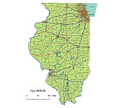
The Illinois State vector road map is a must-have for designers and anyone who wants a comprehensive and detailed map of Illinois. With its clear road signs and markings, it makes navigating the state a breeze. The map includes all major roads, highways, and state roads, as well as important settlements. What sets this map apart is its versatility – you can easily customize it by adding your own colors and highlighting points of interest. Available in Adobe Illustrator, PDF, and high-resolution JPG formats, it’s a valuable resource for designers and a handy tool for anyone exploring or planning a trip to Illinois.
Layers
-county name black of state Illinois
-country name white of state Illinois
-names of rivers, lakes of state Illinois
-capital sign of state Illinois
-highway symbols of state Illinois
-road signs state Illinois
-city names of state Illinois
-highway – lines of state Illinois
-A road lines of state Illinois
-B road lines of state Illinois
-C road lines of state Illinois
-lakes of state Illinois
-rivers of state Illinois
-urban areas of state Illinois
-state border os state Illinois
-counties of state Illinois
Counties:
Metro Areas:
Major Cities:
North-South interstates include: Interstate 39, Interstate 55 and Interstate 57. East-West interstates include: Interstate 24, Interstate 64, Interstate 70, Interstate 72, Interstate 74, Interstate 80, Interstate 88, Interstate 90, Interstate 94 and Interstate 294.Illinois Routes:

Illinois Highways, State Roads, Rivers, Main Cities, Locations, Counties.printable Map.
Other Illinois map: 5 digit zip code map
The Illinois State vector road map. file in vector format enable the user organise level of structuring of map.
A vector file (ai, pdf) has flexible tools for displaying elements of maps
- you can discrete or arbitrary scaling map
- performing group operation with selected features
- changing the orders of displaying layers
- switching in/off displaying os any layers
- changing attributes of selected object ( recolour, modify outline thick, transparency, symbols)
- adding or changing features of any items, (i.e. font type)
- copying and moving particular shapes
- merging different shapes (i.e. counties)
- adding, removing cartography symbols
For editing ai, pdf file use the most common Adobe Illustrator (version 10 or higher) or CorelDRAW (version 10 or higher). If you don't have Adobe Illustrator or Corel you can choose
free open source Inkscape - 57 MB -(Windows, Mac, Linux platform ) or Scribus (Windows, Mac, Linux (54 MB)