
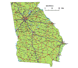
Georgia vector road map with location name, road numbers. AI, PDF layered artwork.
The Georgia vector road map is a fantastic tool for designers and anyone in need of a detailed and customizable map of Georgia state. With its vibrant colors and 17 layers, it allows users to easily edit and print the map according to their specific needs. This map includes cities, rivers, and roads, making it a comprehensive resource for both design projects and general reference. Whether you’re a designer looking for a versatile map or just someone interested in exploring Georgia, this vector map is definitely worth considering.
 | Layers -county name black of state Georgia -country name white of state Georgia -names of rivers, lakes of state Georgia -capital sign of state Georgia -highway symbols of state Georgia -road signs state Georgia -city names of state Georgia -highway – lines of state Georgia -A road lines of state Georgia -B road lines of state Georgia -C road lines of state Georgia -lakes of state Georgia -rivers of state Georgia -urban areas of state Georgia -state border os state Georgia -counties of state Georgia |
Major counties
Bibb, Chatham, Cherokee, Clayton, Cobb, DeKalb, Forsyth, Fulton, Gwinnett, Hall, Henry, Houston, Muscogee, Paulding, Richmond
Counties in Georgia vector road map
Appling, Atkinson, Bacon, Baker, Baldwin, Banks, Barrow, Bartow, Ben Hill, Berrien, Bibb, Bleckley, Brantley, Brooks, Bryan, Bulloch, Burke, Butts, Calhoun, Camden, Candler, Carroll, Catoosa, Charlton, Chatham, Chattahoochee, Chattooga, Cherokee, Clarke, Clay, Clayton, Clinch, Cobb, Coffee, Colquitt, Columbia, Cook, Coweta, Crawford, Crisp, Dade, Dawson, DeKalb, Decatur, Dodge, Dooly, Dougherty, Douglas, Early, Echols, Effingham, Elbert, Emanuel, Evans, Fannin, Fayette, Floyd, Forsyth, Franklin, Fulton, Gilmer, Glascock, Glynn, Gordon, Grady, Greene, Gwinnett, Habersham, Hall, Hancock, Haralson, Harris, Hart, Heard, Henry, Houston, Irwin, Jackson, Jasper, Jeff Davis, Jefferson, Jenkins, Johnson, Jones, Lamar, Lanier, Laurens, Lee, Liberty, Lincoln, Long, Lowndes, Lumpkin, Macon, Madison, Marion, McDuffie, McIntosh, Meriwether, Miller, Mitchell, Monroe, Montgomery, Morgan, Murray, Muscogee, Newton, Oconee, Oglethorpe, Paulding, Peach, Pickens, Pierce, Pike, Polk, Pulaski, Putnam, Quitman, Rabun, Randolph, Richmond, Rockdale, Schley, Screven, Seminole, Spalding, Stephens, Stewart, Sumter, Talbot, Taliaferro, Tattnall, Taylor, Telfair, Terrell, Thomas, Tift, Toombs, Towns, Treutlen, Troup, Turner, Twiggs, Union, Upson, Walker, Walton, Ware, Warren, Washington, Wayne, Webster, Wheeler, White, Whitfield, Wilcox, Wilkes, Wilkinson, Worth on Georgia vector road map
Metro areas on Georgia vector road map
Albany Area, Americus Area, Athens Area, Atlanta Area, Augusta Area, Bainbridge Area, Brunswick Area, Calhoun Area, Cedartown Area, Chattanooga Area, Columbus Area, Cordele Area, Cornelia Area, Dalton Area, Douglas Area, Dublin Area, Fitzgerald Area, Gainesville Area, Hinesville Area, Jefferson Area, Jesup Area, LaGrange Area, Macon Area, Milledgeville Area, Moultrie Area, Rome Area, Savannah Area, St. Marys Area, Statesboro Area, Summerville Area, Thomaston Area, Thomasville Area, Tifton Area, Toccoa Area, Valdosta Area, Vidalia Area, Warner Robins Area, Waycross Area
Major cities
Acworth, Albany, Alpharetta, Atlanta, Brookhaven, Canton, Carrollton, Cartersville, Columbus, Dalton, Decatur, Douglasville, Duluth, Dunwoody, East Point, Gainesville, Griffin, Hinesville, Johns Creek, Kennesaw, LaGrange, Lawrenceville, Macon, Marietta, McDonough, Milton, Newnan, Peachtree City, Peachtree Corners, Pooler, Rome, Roswell, Sandy Springs, Savannah, Smyrna, Statesboro, Stockbridge, Sugar Hill, Union City, Valdosta, Warner Robins, Woodstock
Georgia Interstates:
North-South interstates include: Interstate 59, Interstate 75, Interstate 85, Interstate 95 and Interstate 185. East-West interstates include: Interstate 16 and Interstate 20.Georgia Routes:
US Highways and State Routes include: Route 1, Route 17, Route 19, Route 23, Route 25, Route 27, Route 27A, Route 29, Route 41, Route 76, Route 78, Route 80, Route 82, Route 84, Route 129, Route 221, Route 278, route 280, Route 301, Route 319, Route 341, Route 378 and Route 441.

Other Florida map:Detail of Florida state county vector map with subdivision ai,pdf, file South Atlantic region sates. 8 states county map
The Georgia vector road map. file in vector format enable the user organise level of structuring of map.
A vector file (ai, pdf) has flexible tools for displaying elements of maps
- you can discrete or arbitrary scaling map
- performing group operation with selected features
- changing the orders of displaying layers
- switching in/off displaying os any layers
- changing attributes of selected object ( recolour, modify outline thick, transparency, symbols)
- adding or changing features of any items, (i.e. font type)
- copying and moving particular shapes
- merging different shapes (i.e. counties)
- adding, removing cartography symbols
For editing ai, pdf file use the most common Adobe Illustrator (version 10 or higher) or CorelDRAW (version 10 or higher). If you don't have Adobe Illustrator or Corel you can choose
free open source Inkscape - 57 MB -(Windows, Mac, Linux platform ) or Scribus (Windows, Mac, Linux (54 MB)