
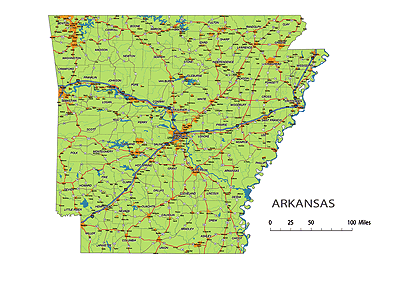
Arkansas State vector road map
 Image Shows Layers Of Adobew Illustrator File |
Layers-county name black of state Arkansas -country name white of state Arkansas -names of rivers, lakes of state Arkansas -capital sign of state Arkansas -highway symbols of state Arkansas -road singns state Arkansas -city names of state Arkansas -highway – lines of state Arkansas -A road lines of state Arkansas -B road lines of state Arkansas -C road lines of state Arkansas -lakes of state Arkansas -rivers of state Arkansas -urban areas of state Arkansas -state border os state Arkansas -counties of state Arkansas |
Counties:
North-South interstates include: Interstate 55. East-West interstates include: Interstate 30 and Interstate 40.Arkansas Routes on map:
US Highways and State Routes include: Route 49, Route 62, Route 63, Route 64, Route 65, Route 67, Route 70, Route 71, Route 79, Route 82, Route 165, Route 167, Route 270, Route 412 and Route 425.

Arkansas Highways, State Roads, Rivers, Main Cities, Locations, Counties.printable Map.
Preview of Arkansas State vector road map: The Arkansas State vector road map showcases the geography features of the state, including the road network, urban areas, cities, rivers, state highways, highway symbols, and road shields. It provides a comprehensive overview of the transportation infrastructure in Arkansas. With a friendly tone and a length of 3-4 sentences, this text serves as an introduction to the map and highlights the key elements it showcases.
Other Arkansas map: Arkansas 5 digit zip code map Detail of Arkansas civil township vector map, county seats of AR
The Preview of Arkansas State vector road map. file in vector format enable the user organise level of structuring of map.
A vector file (ai, pdf) has flexible tools for displaying elements of maps
- you can discrete or arbitrary scaling map
- performing group operation with selected features
- changing the orders of displaying layers
- switching in/off displaying os any layers
- changing attributes of selected object ( recolour, modify outline thick, transparency, symbols)
- adding or changing features of any items, (i.e. font type)
- copying and moving particular shapes
- merging different shapes (i.e. counties)
- adding, removing cartography symbols
For editing ai, pdf file use the most common Adobe Illustrator (version 10 or higher) or CorelDRAW (version 10 or higher). If you don't have Adobe Illustrator or Corel you can choose
free open source Inkscape - 57 MB -(Windows, Mac, Linux platform ) or Scribus (Windows, Mac, Linux (54 MB)