
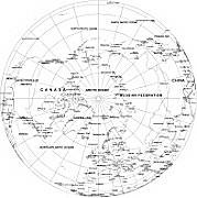
The North Pole Grayscale Map is a fantastic tool for designers and students. With its printed, vector design, this map captures the beauty of the North Pole in stunning black and white. Compatible with Adobe Illustrator and available in PDF format, it is easy to scale and incorporate into various design projects. Whether you’re creating a globe-themed artwork or researching polar regions, this digital file is a must-have. Get your hands on the North Pole Grayscale Map and explore the wonders of the Arctic with style and precision.

The North Pole grayscale map file in vector format enable the user organise level of structuring of map.
A vector file (ai, pdf) has flexible tools for displaying elements of maps
- you can discrete or arbitrary scaling map
- performing group operation with selected features
- changing the orders of displaying layers
- switching in/off displaying os any layers
- changing attributes of selected object ( recolour, modify outline thick, transparency, symbols)
- adding or changing features of any items, (i.e. font type)
- copying and moving particular shapes
- merging different shapes (i.e. counties)
- adding, removing cartography symbols
For editing ai, pdf file use the most common Adobe Illustrator (version 10 or higher) or CorelDRAW (version 10 or higher). If you don't have Adobe Illustrator or Corel you can choose
free open source Inkscape - 57 MB -(Windows, Mac, Linux platform ) or Scribus (Windows, Mac, Linux (54 MB)