
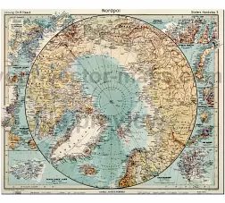
Map of Northern Hemisphere-from1939. This atlas extended through the years of World War II. File size: 15.9 MB. Dimension:4681×4020 px.
Large photo from Stieler Handatlas. German -language map
Extremely detailed, colorful, very meticulous map from the North Pole. In a separate section, the northern gateway, Spitzbergs, Novaja Zemlja, Pandulum Inseln, Greenland, Bering Strait, Franzjosefsfeld, Nordcup.


The Northern Hemisphere-from1939 file in vector format enable the user organise level of structuring of map.
A vector file (ai, pdf) has flexible tools for displaying elements of maps
- you can discrete or arbitrary scaling map
- performing group operation with selected features
- changing the orders of displaying layers
- switching in/off displaying os any layers
- changing attributes of selected object ( recolour, modify outline thick, transparency, symbols)
- adding or changing features of any items, (i.e. font type)
- copying and moving particular shapes
- merging different shapes (i.e. counties)
- adding, removing cartography symbols
For editing ai, pdf file use the most common Adobe Illustrator (version 10 or higher) or CorelDRAW (version 10 or higher). If you don't have Adobe Illustrator or Corel you can choose
free open source Inkscape - 57 MB -(Windows, Mac, Linux platform ) or Scribus (Windows, Mac, Linux (54 MB)