
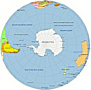
Southern Hemishpere from space – vector artwork. Attention designers! Unleash your creativity with Adobe Illustrator artwork showcasing the Southern Hemisphere.
File Types:
Adobe Illustrator 1,14 MB; layered PDF 0,99MB; JPG 1,82 MB
Where located South Pole?
he South Pole is the southernmost point on Earth and is located at the geographic South Pole. Unlike the North Pole, which is situated in the Arctic Ocean, the South Pole is located on the continent of Antarctica. It is the point where the Earth’s axis of rotation intersects its surface.

Antartica photorealistic 3d illustration, with transparent background. Here

Geographic Coordinates:
The geographic coordinates of the South Pole are approximately 90 degrees south latitude.
Location:
The South Pole is situated in the central part of Antarctica, at the center of the Antarctic Plateau. The continent is covered by a thick ice sheet, and the South Pole is marked by a research station called the Amundsen-Scott South Pole Station, which is used for scientific research.
- Africa: The southern part of Africa is from south of the Equator. Countries like South Africa, Namibia, Botswana, and others are located here.
- Australia: The entire continent of Australia is from south of the Equator. It is the largest landmass entirely within this hemisphere.
- South America: The majority of South America lies from south of the Equator. Countries like Brazil, Argentina, Chile, and others are part of this hemisphere.
- Antarctica: The southernmost continent, Antarctica, is situated around the South Pole, making it entirely part of the Southern Hemisphere.
- Southern Ocean: This ocean surrounds Antarctica and is often considered the southern extension of the Atlantic, Indian, and Pacific Oceans.
Other Globe maps
North-pole-centered-globe-from-space-with-graticules, Africa centered maps, America centered Earth
USA and Canada centered Globe, South Pole centered image of Earth

The Southern Hemisphere from space file in vector format enable the user organise level of structuring of map.
A vector file (ai, pdf) has flexible tools for displaying elements of maps
- you can discrete or arbitrary scaling map
- performing group operation with selected features
- changing the orders of displaying layers
- switching in/off displaying os any layers
- changing attributes of selected object ( recolour, modify outline thick, transparency, symbols)
- adding or changing features of any items, (i.e. font type)
- copying and moving particular shapes
- merging different shapes (i.e. counties)
- adding, removing cartography symbols
For editing ai, pdf file use the most common Adobe Illustrator (version 10 or higher) or CorelDRAW (version 10 or higher). If you don't have Adobe Illustrator or Corel you can choose
free open source Inkscape - 57 MB -(Windows, Mac, Linux platform ) or Scribus (Windows, Mac, Linux (54 MB)