
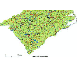
North and South Carolina road map
Unusually, the two states of North and South Carolina draw standard cartographic elements in a single file.
Neighboring states are not on the map during display.
Main Cities
Cameron, Elloree, Piewdoo, Bowman, HIgh Point, Fayetteville, Asheville, Winston-Salem, Greensboro,Durham, Charlotte, Raleigh, Thomasville, Statesville, St.Stephens, Shelby, Sanford, Salibury, Reidsville, North Belmont, New Bern, Morganton, Monroe, Lumberton, Lexington, Lenoir, Laurinburg,Jacksonville, Hickory, Henderson, Havelock,
Main rivers
Lake Norman, Lake Waccamaw, Hyco Lake, Lake Gaston, L.Wylie, L.Tillery, Badin L. HIgh Rock L., L.James
Main roads
Highways:185, 95, 85, 77, 40, 26
State roads: 76, 74, 701, 70, 64, 52, 501, 421
North and South Carolina road map.

Layers
- names of rivers, lakes
- capital sign
- highway symbols
- road signs
- city name
- city seat sings
- highway lines
- A road lines
- B road lines
- C road lines
- lakes shapes
- rivers lines
- urban area shape
- state boundary
- counties shapes
The North and South Carolina road map file in vector format enable the user organise level of structuring of map.
A vector file (ai, pdf) has flexible tools for displaying elements of maps
- you can discrete or arbitrary scaling map
- performing group operation with selected features
- changing the orders of displaying layers
- switching in/off displaying os any layers
- changing attributes of selected object ( recolour, modify outline thick, transparency, symbols)
- adding or changing features of any items, (i.e. font type)
- copying and moving particular shapes
- merging different shapes (i.e. counties)
- adding, removing cartography symbols
For editing ai, pdf file use the most common Adobe Illustrator (version 10 or higher) or CorelDRAW (version 10 or higher). If you don't have Adobe Illustrator or Corel you can choose
free open source Inkscape - 57 MB -(Windows, Mac, Linux platform ) or Scribus (Windows, Mac, Linux (54 MB)