
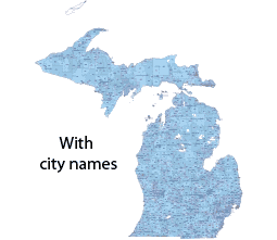

Michigan 5 digit zip code map with city names.The file showing standard zip codes shows the names of the primary cities in addition to the 5-digit number. The individual shape is marked with different colors, but the numbers belonging to the same settlement form the same group. The numbers, the names of the settlements, the terms of the counties, and the borders of the county are grouped by layer. The projection is the same as that of Google or Bing maps.
Illustrator cs5 version is the file type.
Michigan state Zip Code types
Michigan ZIP Codes is the range for 01001 to 05544. How many zip codes are in Michigan? Michigan has a total of 1170 zip codes. 910 Standard, 196 PO BOX, 64 Unique.
Free Michigan zip code list-2023. Excel file
The Header of Excel file
| zip_code | typ | primary_city | acceptable_cities | state | county | timezone | area_codes | est_population | |
| 48001 | STANDARD | Algonac | Clay, Pearl Beach, Russell Is, Russell Island | MI | St. Clair County | America/Detroit | 226, 519, 548, 586, 810 | 10800 | |
| 48002 | STANDARD | Allenton | Berlin, Berville | MI | St. Clair County | America/Detroit | 586, 810 | 2980 | |
| 48003 | STANDARD | Almont | MI | Lapeer County | America/Detroit | 586, 810 | 6340 | ||
| 48004 | PO BOX | Anchorville | MI | St. Clair County | America/Detroit | 586 | 142 | ||
| 48005 | STANDARD | Armada | MI | Macomb County | America/Detroit | 586, 810 | 5050 | ||
| 48006 | STANDARD | Avoca | Fargo, Greenwood, Kenockee | MI | St. Clair County | America/Detroit | 810 | 3700 | |
| 48007 | PO BOX | Troy | MI | Oakland County | America/Detroit | 248 | 0 | ||
| 48009 | STANDARD | Birmingham | MI | Oakland County | America/Detroit | 248, 947 | 19840 | ||
| 48012 | PO BOX | Birmingham | MI | Oakland County | America/Detroit | 248 | 285 | ||
| 48014 | STANDARD | Capac | Mussey | MI | St. Clair County | America/Detroit | 810 | 4050 | |
| 48015 | STANDARD | Center Line | MI | Macomb County | America/Detroit | 586 | 6860 | ||
| 48017 | STANDARD | Clawson | MI | Oakland County | America/Detroit | 248, 947 | 10090 | ||
| 48021 | STANDARD | Eastpointe | East Detroit | MI | Macomb County | America/Detroit | 313, 586 | 29230 | |
| 48022 | STANDARD | Emmett | MI | St. Clair County | America/Detroit | 810 | 2460 | ||
| 48023 | STANDARD | Fair Haven | Ira | MI | St. Clair County | America/Detroit | 586, 810 | 4490 |
massachusetts zip code map printable
massachusetts zip codes by town
zip codes massachusetts list
massachusetts zip codes by county
names of cities in massachusetts and
massachusetts zip code list excel
massachusetts united states zip code
massachusetts zip codes range
usps zip codes massachusetts
zip code western massachusetts
massachusetts area codes map
The Michigan 5 digit zip code map file in vector format enable the user organise level of structuring of map.
A vector file (ai, pdf) has flexible tools for displaying elements of maps
- you can discrete or arbitrary scaling map
- performing group operation with selected features
- changing the orders of displaying layers
- switching in/off displaying os any layers
- changing attributes of selected object ( recolour, modify outline thick, transparency, symbols)
- adding or changing features of any items, (i.e. font type)
- copying and moving particular shapes
- merging different shapes (i.e. counties)
- adding, removing cartography symbols
For editing ai, pdf file use the most common Adobe Illustrator (version 10 or higher) or CorelDRAW (version 10 or higher). If you don't have Adobe Illustrator or Corel you can choose
free open source Inkscape - 57 MB -(Windows, Mac, Linux platform ) or Scribus (Windows, Mac, Linux (54 MB)