
Massachusetts zip code map, PDF and AI Adobe Illustrator (CS5) file. For GIS software shape file.
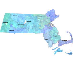
County map 50 % transparent. One location name ( usually of larger cities) – one color for all zip code shape.
The Massachusetts zip codes map is a comprehensive and visually appealing product that provides you with all the necessary information you need when it comes to navigating the state. With its Illustrator artwork on 5 layers, this map is both engaging and informative.
Featuring graphic artwork that depicts all standard zip codes, you can easily locate any area within Massachusetts. But that’s not all – the product also includes a free download .xlsx file that contains not only standard zip codes but also POBOX and Unique zip codes. This ensures that you have access to the most up-to-date and detailed information.
Massachusetts all zip codes xlsx file
Columns of Excel file:
| zip_code | typ | primary_city | acceptable_cities | state | county | timezone | area_codes | est_population | |
| 01001 | STANDARD | Agawam | MA | Hampden County | America/New_York | 413, 860, 959 | 15410 |
Layer structure
-county name
-county shape
-zip code number
-primary city name
– standard zip code shape

The Massachusetts zip code map file in vector format enable the user organise level of structuring of map.
A vector file (ai, pdf) has flexible tools for displaying elements of maps
- you can discrete or arbitrary scaling map
- performing group operation with selected features
- changing the orders of displaying layers
- switching in/off displaying os any layers
- changing attributes of selected object ( recolour, modify outline thick, transparency, symbols)
- adding or changing features of any items, (i.e. font type)
- copying and moving particular shapes
- merging different shapes (i.e. counties)
- adding, removing cartography symbols
For editing ai, pdf file use the most common Adobe Illustrator (version 10 or higher) or CorelDRAW (version 10 or higher). If you don't have Adobe Illustrator or Corel you can choose
free open source Inkscape - 57 MB -(Windows, Mac, Linux platform ) or Scribus (Windows, Mac, Linux (54 MB)