
Adobe Cs5 version file. Maryland zip code county road map
The file shows the geographic location of postal code numbers on precisely edited overlapping layers. The network of semi-transparent counties and main roads show an important element of marketing planning. 5.8 MB.
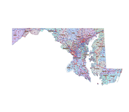
About Maryland map artwork
Maryland zip codes and road map is a comprehensive and visually appealing product that provides you with all the information you need about the zip codes and road network in Maryland. With its Illustrator artwork on 7 layers, this map is not only visually engaging but also highly informative.
The graphic artwork included in this map depicts all standard zip codes, making it easy for you to locate specific areas within Maryland. Additionally, you will also receive a free download .xlsx file that includes standard, POBOX, and Unique zip codes, ensuring that you have access to the most detailed and accurate information.
The map features county names, estimated population, and time zone information, conveniently organized in columns headers. This allows you to quickly find the relevant information you need for any specific area in Maryland.
Whether you are a resident, business owner, or simply curious about the zip codes and road network in Maryland, this product is a valuable resource. Get your Maryland zip codes and road map today and explore the state with confidence and ease.
Maryland all zip codes, .xlsx file
Download Maryland all zip codes Excel file
Zip code types of Maryland state
Maryland ZIP Codes is the range from 20588 to 21930. How many zip codes are in Maryland: 622
Standard: 425, PoBox:141, Unique:56

The Maryland zip code county road map file in vector format enable the user organise level of structuring of map.
A vector file (ai, pdf) has flexible tools for displaying elements of maps
- you can discrete or arbitrary scaling map
- performing group operation with selected features
- changing the orders of displaying layers
- switching in/off displaying os any layers
- changing attributes of selected object ( recolour, modify outline thick, transparency, symbols)
- adding or changing features of any items, (i.e. font type)
- copying and moving particular shapes
- merging different shapes (i.e. counties)
- adding, removing cartography symbols
For editing ai, pdf file use the most common Adobe Illustrator (version 10 or higher) or CorelDRAW (version 10 or higher). If you don't have Adobe Illustrator or Corel you can choose
free open source Inkscape - 57 MB -(Windows, Mac, Linux platform ) or Scribus (Windows, Mac, Linux (54 MB)