
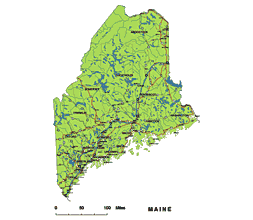
Maine state vector road map
This is a general, ready -to -print map showing larger cities, rivers and main roads on well -visible layers. PDF, AI (CS5) format
Counties on canvas:
Androscogginmaine
Aroostook
Cumberland
Franklin
Hancock
Kennebec
Knox
Lincoln
Oxford
Penobscot
Piscataquis
Sagadahoc
Somerset
Waldo
Washington
York
The easternmost cities are Eastport and Lubec. Maine’s northernmost settlement is estcourt station. Main’s largest lake is Lake Moosehead, plus significant lakes in Lake Champlain and South Twin Lake. The Katahdin Mountain is the North terminal of the Appalachi route, the southern terminal is the Springer Mountains of Georgia.
The names of the following settlements can be found on the map:
There are a total of 457 cities in Maine. The 10 largest cities in the population are Portland, Lewiston, Bangor, South Portland, Auburn, Biddeford, Sanford, Saco, Augusta and Westbrook.
Despite the fact that Maine is not one of the largest states, its population is evenly distributed between the counties.
Westbrook Waterville South Portland SanfordSaco Presque Isle,Brunswick Biddeford Bath Auburn Lewiston Bangor.
UGUSTAP ortland Winslow Skowhegan Rumford Rockland Orono Old Town Old Orchard Beach Millinocket AFB Loring Kittery Houlton Gardiner Ellsworth Caribou. Brewer BelfastYork CenterYarmouth Winthrop WiltonVan Buren Topsham Thomaston Springvale South Paris South Berwick
Scarborough Pittsfield Oakland NorwayMilo Mexico Mechanic Falls Madison Madawaska Livermore Falls Lisbon FallsLincoln Kennebunk Hampden Hallowell. Gorham Fort Kent Fort Fairfield Farmington Farmingdale Fairfield East Millinocke tDover-Foxcroft Dexter Cumberland Center Camden Calais
Additional cities
Bucksport Boothbay Harbor Berwick Bar Harbor Woodland Winterport. Washburn Waldoboro Veazie Southwest HarborSouth EliotSearsport. Sabattus Richmond
But these are also city names
Randolph Patten Ogunquit North Berwick Norridgewock Newport MilfordMars Hill-Blaine MachiasLittle Falls-South Windham Lisbon-Lisbon Center Limestone Kittery Point Kennebunkport Jonesport Howland Hartland Guilford Greenville Fryeburg Freepor tFalmouth Foreside Eastport Dixfield Damariscotta-Newcastle Clinton Chisholm Brunswick Station Bridgton Bingham
 |
| Layers -county name black of state Maine -country name white of state Maine -names of rivers, lakes of state Maine -capital sign of state Maine -highway symbols of state Maine -road signs state Maine -city names of state Maine -highway – lines of state Maine -A road lines of state Maine -B road lines of state Maine -C road lines of state Maine -lakes of state Maine -rivers of state Maine -urban areas of state Maine -state border os state Maine -counties of state Maine |
More Maine maps:
The Maine state pdf and illustrator map file in vector format enable the user organise level of structuring of map.
A vector file (ai, pdf) has flexible tools for displaying elements of maps
- you can discrete or arbitrary scaling map
- performing group operation with selected features
- changing the orders of displaying layers
- switching in/off displaying os any layers
- changing attributes of selected object ( recolour, modify outline thick, transparency, symbols)
- adding or changing features of any items, (i.e. font type)
- copying and moving particular shapes
- merging different shapes (i.e. counties)
- adding, removing cartography symbols
For editing ai, pdf file use the most common Adobe Illustrator (version 10 or higher) or CorelDRAW (version 10 or higher). If you don't have Adobe Illustrator or Corel you can choose
free open source Inkscape - 57 MB -(Windows, Mac, Linux platform ) or Scribus (Windows, Mac, Linux (54 MB)