
File description
You will get 2 files.
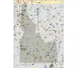
First file: Idaho and the neighboring states 6.8MB
Second file: Cut out map of Idaho 2.5 MB
Introducing
the Idaho Road City Map – your ultimate guide to navigating the beautiful state of Idaho. This highly detailed and informative map is designed using Adobe Illustrator vector technology, ensuring unparalleled clarity and accuracy.
With the inclusion of neighboring states, this map provides a comprehensive view of the entire region, making it an essential tool for travelers and locals alike. The map is thoughtfully organized into 20 layers, allowing you to easily access specific information such as the Highway System Numbering, Populated Places, Main Rivers, and Lakes.
One of the standout features of this map is its editability, giving you the freedom to customize it according to your specific needs. Whether you’re planning a road trip, studying the geography of Idaho, or simply exploring the cities and towns within the state, this map is your reliable companion.
Thanks to its printable format, you can conveniently carry this map with you on your adventures, ensuring that you always have access to valuable information about Idaho’s roads and cities. Say goodbye to getting lost and hello to efficient navigation with the Idaho Road City Map.
Get your hands on the Idaho Road City Map today and unlock the full potential of your Idaho explorations. Don’t miss out on this invaluable resource for travelers, adventurers, and geography enthusiasts.


Maybe you might be interested
Idaho zip code map
Idaho vector county map, colored.ai, pdf, 300 dpi jpg
Counties of Mountain region 8 state county map
Detail of counties and municipalities of Idaho state.
Boise city, Idaho, printable vector map.
Metadata
Tags:detailed map of Idaho roads, free printable Idaho road map, Idaho road map with cities, Idaho road maps free, printable road map of Idaho, Idaho road map with counties, Idaho state highway system map,
detailed map of Idaho with cities, Idaho with County Boundaries vector, Idaho with County Boundaries map, Idaho with County Boundaries,
The Idaho road city map file in vector format enable the user organise level of structuring of map.
A vector file (ai, pdf) has flexible tools for displaying elements of maps
- you can discrete or arbitrary scaling map
- performing group operation with selected features
- changing the orders of displaying layers
- switching in/off displaying os any layers
- changing attributes of selected object ( recolour, modify outline thick, transparency, symbols)
- adding or changing features of any items, (i.e. font type)
- copying and moving particular shapes
- merging different shapes (i.e. counties)
- adding, removing cartography symbols
For editing ai, pdf file use the most common Adobe Illustrator (version 10 or higher) or CorelDRAW (version 10 or higher). If you don't have Adobe Illustrator or Corel you can choose
free open source Inkscape - 57 MB -(Windows, Mac, Linux platform ) or Scribus (Windows, Mac, Linux (54 MB)