
Free colored vector world map with geography lines.
PDF, EPS, JPG, SVG, WMF, AI format (see download link)
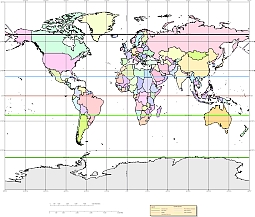
For cylindrical projections, only one standard parallel is specified. The other standard parallel is the same latitude with the opposite sign. For this projection, the standard parallel is by definition fixed at 45º.
This projection was presented by James Gall in 1855. It is also known simply as the Gall projection. It is a special form of the Braun Perspective Cylindrical projection secant at 45ºN and S.
Graticule
Meridians: Equally spaced straight parallel lines 0.77 as long as the Equator.
Parallels: Unequally spaced straight parallel lines, perpendicular to the meridians. Spacing increases toward the poles.Symmetry: About any meridian or the Equator.
Symmetry: About any meridian or the Equator.
Free colored vector world map for presentation, print.
Show some love… for your free map
Free colored vector world map

The Free colored vector world map file in vector format enable the user organise level of structuring of map.
A vector file (ai, pdf) has flexible tools for displaying elements of maps
- you can discrete or arbitrary scaling map
- performing group operation with selected features
- changing the orders of displaying layers
- switching in/off displaying os any layers
- changing attributes of selected object ( recolour, modify outline thick, transparency, symbols)
- adding or changing features of any items, (i.e. font type)
- copying and moving particular shapes
- merging different shapes (i.e. counties)
- adding, removing cartography symbols
For editing ai, pdf file use the most common Adobe Illustrator (version 10 or higher) or CorelDRAW (version 10 or higher). If you don't have Adobe Illustrator or Corel you can choose
free open source Inkscape - 57 MB -(Windows, Mac, Linux platform ) or Scribus (Windows, Mac, Linux (54 MB)