
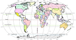
Colored world map. Robinson projection.
PDF, EPS, JPG, SVG, WMF, AI format (see download link)
Ellipsoid globe map is a part of free digitalmaps collection. The file is part of the 144 freely downloadable world representations. Earth representations avaiblable in the most familiar projection. These are Mercator, Robinson, Moollweide, Plate Carreé.The ellipsoid idea is facilitated by the grawticules that appear every 30 degrees.
Adobe Illustrator layers:
- graticules
- geogrids (Equator, Tropic of Canser, Tropic of Capricorn, Artarctic Circle, Artic Circle
- country shapes

The Ellipsoid Globe map with geogrid file in vector format enable the user organise level of structuring of map.
A vector file (ai, pdf) has flexible tools for displaying elements of maps
- you can discrete or arbitrary scaling map
- performing group operation with selected features
- changing the orders of displaying layers
- switching in/off displaying os any layers
- changing attributes of selected object ( recolour, modify outline thick, transparency, symbols)
- adding or changing features of any items, (i.e. font type)
- copying and moving particular shapes
- merging different shapes (i.e. counties)
- adding, removing cartography symbols
For editing ai, pdf file use the most common Adobe Illustrator (version 10 or higher) or CorelDRAW (version 10 or higher). If you don't have Adobe Illustrator or Corel you can choose
free open source Inkscape - 57 MB -(Windows, Mac, Linux platform ) or Scribus (Windows, Mac, Linux (54 MB)