
Other free vector El Salvador map (link)
Black and white El-Salvador free vector map-2 in EPS format.
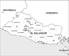
Silhoutette map of country. El Salvador (officially, the Republic of El Salvador) is divided into 14 departments (departamentos, sing. departamento). In alphabetical order, the departments are: Ahuachapan, Cabanas, Chalatenango, Cuscatlan, La Libertad, La Paz, La Union, Morazan, San Miguel, San Salvador, San Vicente, Santa Ana, Sonsonate and Usulutan. See on map !

The El-Salvador free vector map-2 file in vector format enable the user organise level of structuring of map.
A vector file (ai, pdf) has flexible tools for displaying elements of maps
- you can discrete or arbitrary scaling map
- performing group operation with selected features
- changing the orders of displaying layers
- switching in/off displaying os any layers
- changing attributes of selected object ( recolour, modify outline thick, transparency, symbols)
- adding or changing features of any items, (i.e. font type)
- copying and moving particular shapes
- merging different shapes (i.e. counties)
- adding, removing cartography symbols
For editing ai, pdf file use the most common Adobe Illustrator (version 10 or higher) or CorelDRAW (version 10 or higher). If you don't have Adobe Illustrator or Corel you can choose
free open source Inkscape - 57 MB -(Windows, Mac, Linux platform ) or Scribus (Windows, Mac, Linux (54 MB)