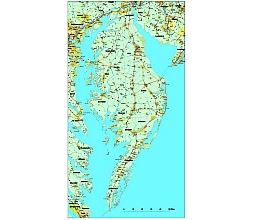
The Delmarva Peninsula, or simply Delmar, is a large peninsula,The border between Maryland and Delaware,
All three counties in Delaware—New Castle (partially), Kent, and Sussex—are located on the peninsula. Of the 23 counties in Maryland, nine are on the Eastern Shore: Kent, Queen Anne’s, Talbot, Caroline, Dorchester, Wicomico, Somerset, and Worcester, as well as a portion of Cecil County. Two Virginia counties are on the peninsula: Accomack and Northampton.
Delmar vector map includes major roads and major settlements, rivers and signs for major roads. In addition, the names and boundaries of the counties. There are a total of 16 layers in the Adobe Illustrator file. (cs5 version)
zip file 10.5 MB
Share this !
The Delmar Peninsula vector map file in vector format enable the user organise level of structuring of map.
A vector file (ai, pdf) has flexible tools for displaying elements of maps
- you can discrete or arbitrary scaling map
- performing group operation with selected features
- changing the orders of displaying layers
- switching in/off displaying os any layers
- changing attributes of selected object ( recolour, modify outline thick, transparency, symbols)
- adding or changing features of any items, (i.e. font type)
- copying and moving particular shapes
- merging different shapes (i.e. counties)
- adding, removing cartography symbols
For editing ai, pdf file use the most common Adobe Illustrator (version 10 or higher) or CorelDRAW (version 10 or higher). If you don't have Adobe Illustrator or Corel you can choose
free open source Inkscape - 57 MB -(Windows, Mac, Linux platform ) or Scribus (Windows, Mac, Linux (54 MB)


