
Latitude-longitude grid at interval 30 degrees
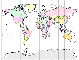
Colored gall world vector map. PDF, EPS, JPG, SVG, WMF, AI format (see download link) It is a cylindrical projection with two standard parallels at latitudes 45° N and S. The globe is projected perspectively onto a secant cylinder from the point on the equator opposite a given meridian. Meridians are equally spaced straight lines. Parallels are straight lines with spacing increasing away from the equator. Poles are straight lines.
Show some love… for your free map
Colored gall world vector map

The Colored gall world vector map file in vector format enable the user organise level of structuring of map.
A vector file (ai, pdf) has flexible tools for displaying elements of maps
- you can discrete or arbitrary scaling map
- performing group operation with selected features
- changing the orders of displaying layers
- switching in/off displaying os any layers
- changing attributes of selected object ( recolour, modify outline thick, transparency, symbols)
- adding or changing features of any items, (i.e. font type)
- copying and moving particular shapes
- merging different shapes (i.e. counties)
- adding, removing cartography symbols
For editing ai, pdf file use the most common Adobe Illustrator (version 10 or higher) or CorelDRAW (version 10 or higher). If you don't have Adobe Illustrator or Corel you can choose
free open source Inkscape - 57 MB -(Windows, Mac, Linux platform ) or Scribus (Windows, Mac, Linux (54 MB)