
Large Color pictorial map of Alaska. Dimension: 13693x10190px at 72 dpi
Discover the beauty of Alaska with this vintage color pictorial map of Alaska – a true treasure for designers and students alike.
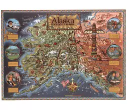
Color pictorial map of Alaska: A vibrant and captivating representation of the 49th state of the United States of America, this color pictorial map showcases the breathtaking beauty and wonders of Alaska. Published during the same year Alaska joined the Union, this map provides a historical glimpse into the state’s early days.
With meticulous detail, the map highlights the intricate network of rivers, straits, sounds, and towns that shape Alaska’s landscape. Mountain ranges are depicted in aerial perspective, offering a unique visual perspective. Glaciers, shaded in white, add a touch of icy splendor to the map.
But it doesn’t stop there. This map is an artistic masterpiece, adorned with lifelike illustrations of wildlife, showcasing the rich biodiversity that thrives in this majestic land. From majestic bears to soaring eagles, the map brings Alaska’s wildlife to life.
The map also includes representations of agricultural products, historical landmarks, oil fields, and fisheries that have played a significant role in shaping Alaska’s economy and history. These illustrative elements truly make this map a visual treat.
To add an extra touch of authenticity and cultural significance, the map border features a geometric beadwork design, paying homage to the indigenous cultures and artistic traditions of Alaska.
For anyone with an appreciation for both geography and art, this color pictorial map of Alaska is a must-have. Whether you’re an avid collector, a history enthusiast, or simply curious about the wonders of Alaska, this map will transport you to the untamed beauty of the Last Frontier.
Keywords: Color pictorial map of Alaska

The Color pictorial map of Alaska file in vector format enable the user organise level of structuring of map.
A vector file (ai, pdf) has flexible tools for displaying elements of maps
- you can discrete or arbitrary scaling map
- performing group operation with selected features
- changing the orders of displaying layers
- switching in/off displaying os any layers
- changing attributes of selected object ( recolour, modify outline thick, transparency, symbols)
- adding or changing features of any items, (i.e. font type)
- copying and moving particular shapes
- merging different shapes (i.e. counties)
- adding, removing cartography symbols
For editing ai, pdf file use the most common Adobe Illustrator (version 10 or higher) or CorelDRAW (version 10 or higher). If you don't have Adobe Illustrator or Corel you can choose
free open source Inkscape - 57 MB -(Windows, Mac, Linux platform ) or Scribus (Windows, Mac, Linux (54 MB)