
WGS1984 projection
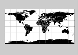
Black filled world outline vector map often used by designers to create schematic maps or for PowerPoint presentations and stock illustrations. Available in all standard vector formats. AI, EPS, SVG, CDR, PDF, WMF.
You simply have to add it to the cart, and it can be downloaded immediately with an email address of your choice without registration. World map silhouette images in 6 vector format. Each country can be edited separately.
Seven continents Africa, Antarctica, Asia, Australia, Europe, North America, and South America.
Black filled world outline vector map
PDF, EPS, JPG, SVG, WMF, AI format (see download link)

Show some love… for your free map
Black filled world outline vector map
Antique world map
The Black filled world outline vector map file in vector format enable the user organise level of structuring of map.
A vector file (ai, pdf) has flexible tools for displaying elements of maps
- you can discrete or arbitrary scaling map
- performing group operation with selected features
- changing the orders of displaying layers
- switching in/off displaying os any layers
- changing attributes of selected object ( recolour, modify outline thick, transparency, symbols)
- adding or changing features of any items, (i.e. font type)
- copying and moving particular shapes
- merging different shapes (i.e. counties)
- adding, removing cartography symbols
For editing ai, pdf file use the most common Adobe Illustrator (version 10 or higher) or CorelDRAW (version 10 or higher). If you don't have Adobe Illustrator or Corel you can choose
free open source Inkscape - 57 MB -(Windows, Mac, Linux platform ) or Scribus (Windows, Mac, Linux (54 MB)