
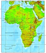
Africa terrain map includes 25 vector layers. Background raster pic: 3411 x 3890 pix
File size: 17 MB.
Rivers on map: Atbara, Tajo, Shatt al Arab, Abay, Suez Canal, Gharraf Canal, Tejo (Tagus), Albert Nile,Bamingui, Mouhoun (Black Volta), El Bahr el Abyad, (White Nile), El Bahr el Azraq (Blue Nile), Lualaba (Congo), Mangoky, Nakanbé (White Volta), Victoria Nile, Busira, Bénoué, Okavango, Atbara, Sassandra, JordanKibali, Kagera, Lualaba, SetitSanaga, Semliki Al FuratLomGenal, Bafing, Tshuapa, Ouham, Euphrates, Ruvuma, Ubangi, DicleVolta, ShireSénégal, JubbaKadéï, Limpopo, Kafue, BenueCubang, oChariOmo, KwangoTajo, VaalFirat Zambezi, Tigris, Orange, KasaiNiger, Congo, Uele, Nile
54 States on Africa Terrain Maps
List of Africa states
Africa is home to 54 recognized countries. Here is a list of African countries:
- Algeria
- Angola
- Benin
- Botswana
- Burkina Faso
- Burundi
- Cabo Verde
- Cameroon
- Central African Republic
- Chad
- Comoros
- Democratic Republic of the Congo
- Djibouti
- Egypt
- Equatorial Guinea
- Eritrea
- Eswatini (formerly Swaziland)
- Ethiopia
- Gabon
- The Gambia
- Ghana
- Guinea
- Guinea-Bissau
- Ivory Coast (Côte d’Ivoire)
- Kenya
- Lesotho
- Liberia
- Libya
- Madagascar
- Malawi
- Mali
- Mauritania
- Mauritius
- Morocco
- Mozambique
- Namibia
- Niger
- Nigeria
- Rwanda
- Sao Tome and Principe
- Senegal
- Seychelles
- Sierra Leone
- Somalia
- South Africa
- South Sudan
- Sudan
- Tanzania
- Togo
- Tunisia
- Uganda
- Zambia
- Zimbabwe
Layers of Africa terrain map

The Africa Terrain Map with country name file in vector format enable the user organise level of structuring of map.
A vector file (ai, pdf) has flexible tools for displaying elements of maps
- you can discrete or arbitrary scaling map
- performing group operation with selected features
- changing the orders of displaying layers
- switching in/off displaying os any layers
- changing attributes of selected object ( recolour, modify outline thick, transparency, symbols)
- adding or changing features of any items, (i.e. font type)
- copying and moving particular shapes
- merging different shapes (i.e. counties)
- adding, removing cartography symbols
For editing ai, pdf file use the most common Adobe Illustrator (version 10 or higher) or CorelDRAW (version 10 or higher). If you don't have Adobe Illustrator or Corel you can choose
free open source Inkscape - 57 MB -(Windows, Mac, Linux platform ) or Scribus (Windows, Mac, Linux (54 MB)